Good window tomorrow AM

Western Australia Surf Forecast by Craig Brokensha (issued Wednesday 25th November)
Best Days: Early-mid morning tomorrow, keen surfers Perth and Mandurah Friday AM, Saturday morning protected spots, Sunday morning in the South West
Recap
Light winds and OK conditions yesterday morning with a small to tiny swell across all locations, deteriorating through the day with strong sea breezes kicking in (a change in the South West).
Today there was a peaky windswell from yesterday's sea breeze breaking in Perth and Mandurah with early workable winds, bumpy in the South West with a slight kick in size.
Conditions have since cleaner up in the South West and a larger SW groundswell is yet to really show with sets to 6ft or so, but should arrive any minute as winds swing back to being best for protected spots.
This week and weekend (Nov 26 - 29)
This afternoon's large SW groundswell was generated by a strong, slow moving low that formed south-west of us earlier this week and we should see the Margaret River region reaching 8ft+ later today with a late kick to 3ft on the sets in Mandurah and 2-3ft in Perth.
This swell will peak overnight and ease through tomorrow, dropping from 6-8ft across the South West, 2-3ft in Perth and Mandurah.
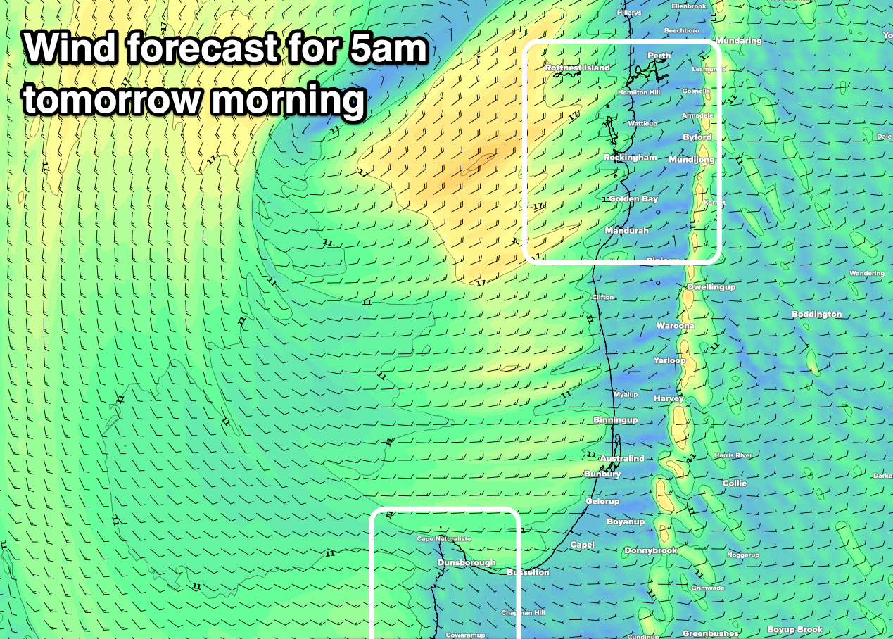
Winds are tricky but favourable early as a surface trough and low drift south-west across us early morning before sitting just south-west of Rottnest Island, then drifting back south-east through the morning, dragging winds onshore.
Margs will be the cleanest for longest with a morning E/SE offshore due to become variable mid-morning before shifting onshore late morning, while Perth and Mandurah will see dawn E/NE winds, shifting quickly to the N/NE and the fresh N/NW late morning. All coasts will then see strong S/SW winds in the wake of the trough/low into the afternoon.
Therefore get out there earlier rather than later.
Friday will remain onshore but only moderate in strength across the South West as the swell continues to ease, with better S/SE winds further north but the size will be back to 1-2ft.
Moving into the weekend, our inconsistent SW groundswell is due to fill in Saturday, generated by a strong but tight low west of the Heard Island region earlier this week.
A good fetch of severe-gale to storm-force winds were produced, but the low weakened while tracking north-east, leaving an inconsistent and moderate sized swell.
The swell should build Saturday and peak through from later morning into the afternoon with infrequent 5-6ft sets in the South West, slow and to 2ft in Mandurah and 1-2ft across Perth.
Conditions aren't as favourable any more with a S/SE breeze due across the South West, similar to the north ahead of S/SW sea breezes. Sunday looks cleaner with E/SE offshores in Margs, S/SE to the north but the swell will be easing and dropping from 4ft on the sets in the South West, tiny to the north.
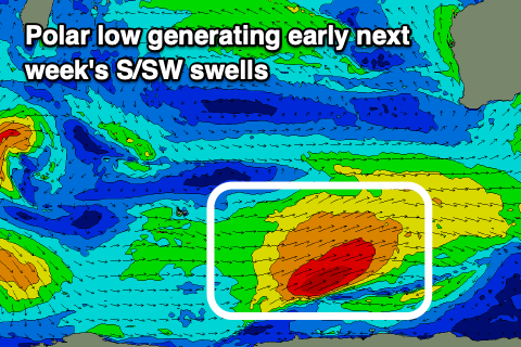 Moving into next week, and a strong, slow moving polar low is forecast to develop in our southern swell window on Friday, with a fetch of strong to gale-force W/SW winds being focussed towards Tasmania. This fetch will weaken, but a weaker front spawning off the back of the low will project north and towards the Bight, generating an additional fetch of strong S/SW winds in our swell window.
We should see two pulses of S/SW swell, the strongest though still mid-period pulse is due Monday, building to 5-6ft across the South West through the day, 1-2ft in Mandurah and 1-1.5ft across Perth, with the secondary weaker swell coming in around 5-6ft in the South West Tuesday.
Monday looks poor and onshore with strong W/SW winds, better Tuesday though not great with fresh S/SE winds and the southerly swell direction. We should see the surf clean right up into Wednesday across all locations but the S/SW swell will be on the ease.
Longer term there's nothing too significant on the cards heading into December, so make the most of the coming swell today and this period.