Poor conditions continue, with better windows next week

Western Australia Surf Forecast by Craig Brokensha (issued Friday 4th September)
Best Days: Early tomorrow Perth and Mandurah, Perth and Mandurah Tuesday morning, Wednesday, Friday
Recap
Large, stormy and terrible conditions across the South West yesterday, a touch smaller though still poor today. Mandurah and Perth saw slightly better conditions yesterday morning, though still not great, similar this morning but a tad smaller.
This weekend and next week (Sep 5 - 11)
Besides an early window of NE winds tomorrow morning around Mandurah and Perth, it's onshore and poor for the outlook until Tuesday morning.
Size wise a reinforcing SW groundswell due later today is expected to ease tomorrow from 6ft+ across the South West, 2-3ft in Mandurah and 2ft across Perth but get in early before winds shift NW and freshen. The South West will be poor all day.
Moving into Sunday and stronger NW tending W/NW winds will develop as a broad and elongated storm starts moving in from the west-southwest.
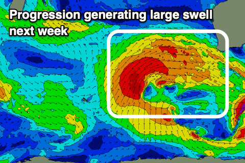 This progression is currently around the Heard Island region, generating strong W/SW-SW winds, but we'll see it strengthen and move closer tomorrow and Sunday with gale-force W/SW winds projecting on top an active sea state.
This will bring building levels of large mid-period W/SW swell ahead of the groundswell Monday and Tuesday but with strong local W'ly winds Monday, easing later and then backing off further Tuesday.
Size wise the South West should reach 12ft+ through Monday, 4ft+ across Mandurah and 3-4ft in Perth, easing Tuesday from 12ft, 3-4ft and 3ft respectively. Winds in Perth and Mandurah should become more variable from the NE Tuesday morning but persist out of the W/NW-NW around Margs.
Wednesday looks better across all locations with an E'ly offshore, though easing surf around half the size of Tuesday morning.
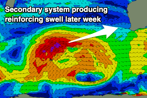 The stronger low that was due to form through early next week will initially be quite significant but quickly weaken, with a burst of severe-gale W/SW winds on top an active sea state due to produce a large, reinforcing W/SW groundswell for Friday.
Winds will unfortunately swing back onhsore Thursday, possibly reverting back offshore Friday for the peak of swell, though we'll review this Monday.
Size wise Margaret River should come in around the 10-12ft range, 3ft+ in Mandurah and 2-3ft across Perth. Have a great weekend!
Comments
INSANE looking for Indo. F#@K!!!
Fulfilling barrels. Really good here last Tuesday very grateful. More this Tuesday by the looks.
Looks like you're in for a cracker also Redclement. (winds permitting) Yew!