Windy tomorrow but improving from Wednesday

Western Australia Surf Forecast by Craig Brokensha (issued Monday 17th August)
Best Days: Wednesday Perth and Mandurah, Thursday, Friday morning Margs, Sunday, Monday morning
Recap
Early OK winds for protected spots out of the north Saturday morning with 4-5ft of swell across the South West, bumpy and to 2ft across Mandurah and 1-2ft in Perth.
Conditions deteriorated through the day with an approaching and deepening mid-latitude low, bringing large and stormy waves to all locations on Sunday.
Today winds are still blowing strong onshore with a bit of a drop in the size of the localised swell.
This week and weekend (Aug 18 - 23)
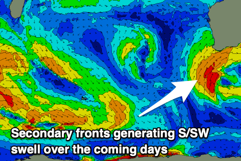
The low linked to the weekend's stormy swell has moved east, but on the backside of it, a couple of stronger fronts have spawned and this will keep conditions poor through tomorrow across all locations, improving from Wednesday as the progression pushes further east.
We'll see strong SW tending S/SW winds tomorrow with large levels of mid-period S/SW swell persisting though starting to ease later in the day. Surf to 8ft+ should persist across the South West, 3ft+ across Mandurah and 2-3ft in Perth.
 Wednesday's improvements in winds look less likely for the South West now which is unfortunate, with lingering and moderate to fresh SW-S/SW winds, cleaner to the north with a light E/NE offshore. The S/SW swell will be on the ease though from 6ft+ across the South West, 2ft in Mandurah and 1ft to possibly 2ft in Perth.
Thursday still looks clean and fun across all locations with a light morning E/NE offshore, variable from the N'th into the afternoon. Our inconsistent W/SW groundswell is also on track, with no change to the expected sized across the regions.
We should see fun though inconsistent 4-6ft waves across the South West, 2ft on the sets in Mandurah and Perth, easing Friday as winds start E/NE at dawn but then freshen and swing more N/NE and then N/NW.
This will be ahead of a weak approaching trough, bringing strong W/SW-SW winds on Saturday that may improve on Sunday as the trough clears east. Some new moderate to large sized W/SW groundswell is expected to build through the weekend from a mid-latitude frontal progression that's formed south-east of South Africa.
A mixed though consistent fetch of strong to gale-force W/SW winds will move through our swell window over the coming days, weakening slowly while dipping south-east once around the Heard Island region.
A slightly smaller swell is expected on Saturday ahead of the swell proper Sunday to 6ft+ across the South West, 2ft+ in Mandurah and 2ft across Perth. If winds are still a little dicey Sunday for the South West, Monday looks much cleaner with light offshores as the swell eases.
More on this and follow up swells on Wednesday.