XXL swell due to peak mid-week

Western Australia Surf Forecast by Craig Brokensha (issued Monday 29th June)
Best Days: Wednesday protected spots (afternoon across the South West), Thursday, Friday
Recap
Poor conditions across the South West Saturday with a moderate sized swell, becoming large and stormy through yesterday and XL today as strong mid-latitude storms pushed into us.
Mandurah was OK early Saturday and a lumpy 2-3ft, peaky and to 2-3ft in Perth with choppy and larger conditions yesterday. Today is a stormy mess with 4-5ft waves across Mandurah and 3-4ft in Perth.
This week and weekend (Jun 30 – Jul 3)
The vigorous front bringing today's first spike of XL stormy swell will drop south-east today resulting in a drop in wind and swell.
When I say drop in wind, we'll still be seeing strong and blowy onshore winds, with the swell easing back temporarily ahead of the XXL long-period SW groundswell on Wednesday.
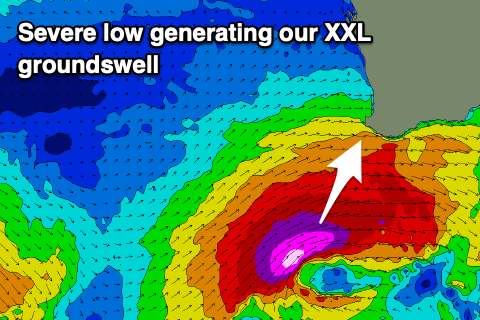 The severe low linked to this swell is developing south-west of us, though a little later than expected. We'll still see severe-gale to storm-force W/SW-SW winds projected through our south-western swell window, with a late increase in size likely tomorrow ahead of a peak Wednesday.
The South West is still expected to come in at 15-20ft, 4-5ft+ across Mandurah and 3-5ft across the Perth swell magnets, easing later in the day and then down steadily Thursday.
Local winds on Wednesday are still expected to improve as high moves in from the west, swinging from a strong S/SW to a weaker S'ly across the South West, while Perth and Mandurah should see S-S/SE tending SE winds through the morning, back to the S/SE into the afternoon and evening.
Thursday looks cleaner again with E'ly offshores across Perth and Mandurah, lighter and more variable SE-E/SE in the South West leaving lumpy and improving conditions. Size wise the South West will likely still be 10ft+, though dropping quickly, 3-4ft across Mandurah and 3ft in 3ft on the sets in Perth.
Friday will become smaller but fun across the South West magnets with an E/NE tending NE breeze, small to the north.
Into the weekend we've got a new mix of long-range and inconsistent long-period swell and mid-range energy from a broad though mixed frontal progression moving through the Indian Ocean.
A broad fetch of strong to near gale-force W/NW winds will produce a fun W/SW swell that should build Saturday afternoon and peak Sunday. The South West should come in 5-6ft, 2ft to sometimes 3ft across Mandurah and 2ft in Perth on the sets though inconsistent.
Winds will deteriorate though and strengthen from N/NE and tend N'ly through the day, with a trough bringing SW tending S winds on Sunday.
The earlier stages of this trough will see a good fetch of W/SW winds projected towards us, producing a fun W/SW groundswell for early next week with improving winds, but we'll have another look at this Wednesday.