Winds slowly improve with large swells to come

Western Australia Surf Forecast by Craig Brokensha (issued Wednesday 22nd April)
Best Days: Tomorrow, Friday, protected spots Saturday, Sunday, Monday morning protected spots
Recap
Large and onshore though workable waves across selected breaks in the South West yesterday, cleaner to the north with early variable winds and 3-4ft sets across Mandurah, 3ft in Perth.
Today is a touch smaller but average with fresher onshore winds.
This week and weekend (Apr 23 - 26)
Today's onshore winds are linked to a strong mid-latitude frontal system clipping the south-west of the state, weakening while it does so. During its earlier stages over the past couple of days it's generated a great fetch of W/SW gales and large new W/SW groundswell for tomorrow.
We should see the South West kick back to 8ft to occasionally 10ft, 3ft to occasionally 4ft in Mandurah and 3ft sets across Perth in the morning, smaller through the afternoon.
Winds will remain an issue around Margs (though workable) and light to moderate onshore from the W/SW, better to the north with a light SE breeze in Mandurah, E/SE across Perth ahead of afternoon sea breezes.
 Unfortunately it looks like Friday will see winds lingering from the W/SW (light to moderate) with cleaner conditions to the north as the swell drops back in size to 6-8ft in the South West, 2-3ft Mandurah and 2ft+ Perth.
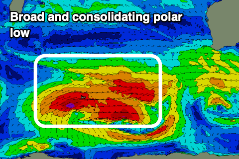
Moving into the weekend and our large, long-period SW groundswell is still on track, with a broad polar low currently forming around the Heard Island region.
There are multiple varying fetches within this system, with pre-frontal gale to severe-gale W'ly winds creating an active sea state for a trailing broad fetch of severe-gale W/SW winds to move on top of.
This will produce a good, long-period SW groundswell that should build through Saturday and peak through the afternoon to 10ft+ across the South West, 3ft+ in Mandurah and 2-3ft in Perth.
The swell should then start to ease Sunday from 8-10ft, 3ft and 2-3ft respectively, slowed by a final fetch of strong to gale-force W/SW winds projecting through our south-western swell window on the weekend, generating a reinforcing SW swell.
Winds won't be ideal Saturday, S/SW across the South West and S/SE-S in Perth and Mandurah, much better Sunday and SE across the South West, E/SE to the north.
We may see winds revert back to the S/SE on Monday morning as the swell continues to ease.
Longer term, besides a localised and average mid-period S/SW swell for Tuesday and Wednesday next week, we could see a new, large W/SW groundswell developing for late in the week/next weekend, but ECMWF isn't on board as of yet. More on this Friday.