Mix of various swells with a couple from the west

Western Australia Surf Forecast by Craig Brokensha (issued Friday 10th April)
Best Days: Margs tomorrow morning, Perth and Mandurah Monday morning, Tuesday morning, Thursday, Friday
Recap
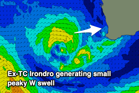
Decent conditions across all locations yesterday morning with a mix of new swell from a poorly aligned storm early this week to our west-southwest and also likely some swell from Tropical Cyclone Irondro.
The swell kicked a bit stronger than expected and has peaked this morning across the South West with windy but clean 6ft+ waves, 2-3ft in Perth and Mandurah. Please remember to only head to the beach for exercise, don't hang around and spread out.
This weekend and next week (Apr 11 - 17)
Today's fun waves will ease into tomorrow leaving small 1ft to occasionally 2ft waves across Perth and Mandurah, better and easing from 4ft on the sets across the South West. Conditions look great with a fresh E/NE offshore, shifting more N/NE and then N/NW into the afternoon.
 Sunday will be a lay day with a low point in swell and onshore W'ly winds as a weakening and small mid-latitude low moves in from the west.
This is actually still the remnants of Tropical Cyclone Irondro and we'll see it project a small fetch of W'ly winds in our western swell windows tomorrow before dipping south-east on Sunday.
A small kick in W'ly swell should be seen later Sunday but more so Monday across Perth and Mandurah to 2ft+ (easing through the day), a touch bigger in the South West but winds will linger onshore from the S/SW-SW. Perth and Mandurah should see early S/SE breezes and fun conditions.
Our slightly better W/SW swell for Tuesday is on track, though the storm looks to be a touch weaker than expected on Wednesday.
A weak fetch of W/SW winds will be projected through our western swell window, dipping south-east on approach. Size wise, the swell is due to build through Tuesday and reach 2ft+ across Perth and Mandurah into the afternoon, 4-6ft across the South West.
Light morning SE breezes are due to swing W'ly and freshen as the swell builds, stronger Wednesday creating poor conditions with as a vigorous polar storm projects up and clips us.
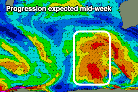 This will be a result of a strong node of the Long Wave Trough developing west-southwest of us, with a stalling polar low forecast to project a series of strong fronts towards us.
The first will see a fetch of broad S/SW-SW gales projected up through our south-western and then southern swell window as it weakens, generating a large SW-S/SW groundswell for mid-late week.
Size wise at this stage it looks like we'll see surf to 8ft+ across the South West, 3ft+ in Mandurah and 2-3ft across Perth Thursday. Margs looks onshore with S/SW-SW winds, better to the north with a morning S/SE breeze. Friday looks the pick with cleaner conditions as the swell eases, but we'll have a closer look at this Monday. Have a great weekend!