Smaller swells but some fun, clean mornings ahead

Western Australia Surf Forecast by Craig Brokensha (issued Wednesday 15th January)
Best Days: South West swell magnets tomorrow morning and Sunday morning, protected spots Wednesday and early Thursday
Recap
Windy but good waves across the South West yesterday with sets in the 6ft range, 2-3ft and clean in Mandurah and 2ft in Perth.
Today the swell has backed off a bit with less favourable winds, limiting surfing options across the coast. Mandurah and protected spots in the South West were the pick.
This week and weekend (Jan 16 - 19)
As touched on in Monday's forecast, we've got some OK pulses of background mid-period swell on the way for the coming days, and conditions tomorrow are looking great.
The first pulse is due overnight tonight, peaking tomorrow with 4-5ft sets across the South West swell magnets, tiny in Perth and Mandurah. An E/SE offshore will create great conditions ahead of sea breezes, poor Friday with a drop in swell and strong S/SE winds.
A low point in swell is due early Saturday but a new slightly smaller mid-period SW swell is expected to build from later morning, kicking to 3-4ft+ and easing from a similar size on Sunday morning in the South West. This is being generated by a weak polar front that's currently north-east of the Heard Island region.
Perth and Mandurah will remain tiny, and winds Saturday look less than favourable, gusty and out of the S/SE to possibly SE in the morning, while Sunday looks the pick with E/SE morning offshores.
Monday will likely be clean again but on the small side.
The slow moving polar frontal progression mentioned on Monday is still on the cards, and so are the onshore winds when it fills in mid-week.
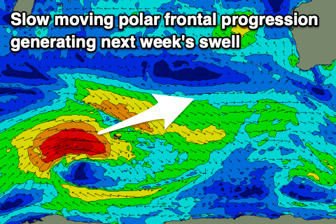 This progression will form south-east of South Africa tomorrow, with a slow moving fetch of gale-force W/SW winds due to push east, weakening once moving across Heard Island and south-west of us. The swell may be seen later Tuesday but a peak is due on Wednesday as a weak trailing front from the progression pushes up and into us, bringing fresh to strong S/SW winds.
Size wise, the South West looks to come in around 6ft to occasionally 8ft, 2-3ft in Mandurah and 2ft across Perth, easing Thursday as S/SW winds persist.
Longer term we may see a strong low forming in our southern swell window later next week, but more on this Friday.