Fun swell for the weekend with favourable winds

Western Australia Surf Forecast by Craig Brokensha (issued Wednesday 11th December)
Best Days: South West magnets tomorrow morning, Saturday morning all locations, South West magnets Sunday morning
Recap
Clean conditions with a small swell to start off yesterday, building into the afternoon but with sea breezes.
Today the swell has peaked with a touch less size than expected, coming in at an inconsistent 4-5ft across the South West with less than perfect conditions, and a bit more size to the north and to 1ft to occasionally 2ft.
This week and weekend (Dec 12 - 15)
We'll see today's swell easing off slowly through tomorrow, more noticeably into Friday with favourable morning winds.
Tomorrow looks best cross the South West with 4ft sets on the swell magnets, back to an infrequent 3ft on the biggest ones Friday morning. Tiny waves are due to the north. Winds will be from a good direction tomorrow but strong out of the E/NE, easing ahead of afternoon sea breezes and then fresh E/NE swinging N and then lighter NW on Friday.
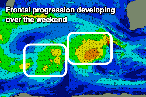 We then look towards our new long-period W/SW groundswell for Saturday, with a strong low forming yesterday, north of the Heard Island region. A short burst of severe-gale to storm-force W'ly winds were picked up by satellite and the low has since spawned into a front and is weakening while tracking east-southeast, with the swell due to arrive overnight Friday and peak Saturday.
This swell will be more consistent and bigger than the current swell, peaking to 6ft to possibly 8ft on the Margaret River swell magnets, 2ft in Mandurah and 1-2ft in Perth.
Winds will be best at dawn and out of the E tending NE and NW late morning ahead of sea breezes.
Conditions look great again Sunday morning with an E/NE offshore, less favourable to the north with S/SE winds and easing sets from 4-5ft in the South West, tiny to the north.
Longer term we've got a slow moving and broad but relatively weak frontal progression forming west-southwest and south-west of us, generating fun levels of W/SW-SW swell through next week. Winds are dicey as the progression nears us, but we'll have a closer look at this Friday.