Fun tomorrow but then average for a while thereafter

Western Australia Surf Forecast by Craig Brokensha (issued Friday 15th November)
Best Days: Swell magnets tomorrow morning, Thursday and Friday mornings
Recap
The swell kicked as expected yesterday, a little bumpy but workable in the South West, clean and fun around Mandurah, tiny to the north.
Today we've got a touch more energy but with strong offshore winds which have since abated in the South West, fun and to 2ft in Mandurah, still tiny but a little bigger in Perth and to 1-1.5ft.
This weekend and next week (Nov 16 - 22)
Another pulse of mid-period W/SW swell should keep similar sized surf hitting all locations into tomorrow morning, 3-5ft Margs, 2ft Mandurah and 1-1.5ft Perth with lighter morning offshore winds. A moderate E/NE'ly is due across all locations, tending variable ahead of sea breezes from midday, so get in through the morning.
Sunday is still looking average with a weak onshore S/SW breeze across the South West with easing small waves, tiny to the north with early variable winds.
Monday should become a little cleaner with a morning S/SE breeze, but the swell will be at a low point with poor surfing options.
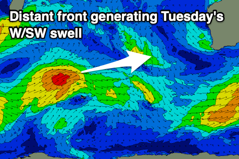 Our new inconsistent mid-period W/SW swell for Tuesday is on track, with a broad but relatively low south-east of South Africa, generating back to back fetches of strong W/SW winds in our far western swell window.
The swell from this source will be a little inconsistent, arriving late Monday but peaking Tuesday to 4-5ft in the South West, 1-2ft in Mandurah and 1-1.5ft across Perth. Winds aren't great though and it looks like a trough will bring a S/SW change to all locations just before dawn, with strengthening onshore W/SW-SW winds Wednesday as a strong front moves in from the south-west
This front and a secondary low look weaker than forecast on Wednesday but we'll still see moderate to large levels of mid-period SW swell developing through the middle to end of next week.
At this stage, the first and best pulse looks to come in at 6-8ft later Wednesday and early Thursday with a window of light E/NE morning winds as it eases. The next pulse is due Friday/Saturday with a change for a morning SE'ly, but more on this Monday. Have a great weekend!