Good swells inbound, though you'll have to work the winds

Western Australia Surf Forecast by Craig Brokensha (issued Friday 11th October)
Best Days: Protected spots tomorrow morning, Mandurah and Perth early Sunday, protected spots Monday morning, Mandurah and Perth Tuesday morning, Margs Wednesday and Thursday mornings
Recap
Easing surf with onshore winds in the South West yesterday and today, lighter to the north.
This weekend and next week (Oct 12 - 18)
These notes will be brief as Ben's on annual leave.
Later today a new long-period SW groundswell is due across the state, mixed in with some mid-period W/SW swell, peaking tomorrow to 6ft to occasionally 8ft across the South West, 2ft+ in Mandurah and 2ft across Perth and winds are still looking less than ideal, S/SE early across all breaks, W/SW-SW into the afternoon.
 Sunday looks poor across the South West as the swell eases as an approaching front brings moderate to fresh W'ly winds, early E/NE around Perth and Mandurah but with small easing surf.
The larger SW groundswell for early next week is still on track and it looks like a trough will move through early in the day, swinging winds from an overnight offshore more to the S/SE in the South West at dawn.
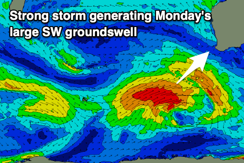
A strong polar low has formed around the Heard Island region and will generate a fetch of severe-gale W/SW winds while projecting up towards us today, weakening slowly while broadening.
A large, long-period SW groundswell for Monday. Margs should build to 8ft+ on the sets through the day, 3ft in Mandurah and 2ft+ across Perth but with that S/SE tending S/sW breeze. Perth and Mandurah may see more variable winds at dawn before S/SW breezes kick in.
Tuesday should still offer size with large easing 6-8ft waves in the South West, 2ft to maybe 3ft in Mandurah and 2ft in Perth but winds will be onshore across the South West, better to the north and SE.
Wednesday looks a bit better with a morning SE wind but the swell will continue to ease, cleaner Thursday but smaller again.
Longer term there's nothing too significant on the cards for the region until early-mid the following week with a vigorous storm forecast to flare up in the southern Indian Ocean later next week. This will hopefully generate a large, long-period W/SW groundswell though the models are still slightly divergent surrounding this. More on the outlook Monday. Have a great weekend!