Large swell with varying winds, plenty of surf days after

Western Australia Surf Forecast by Craig Brokensha (issued Wednesday 2nd October)
Best Days: Thursday, Friday in the South West, later in the day further north, protected spots Saturday morning, the South West Sunday morning and Monday morning, Tuesday morning
Recap
Average waves yesterday morning though the swell kicked in size nicely through the afternoon, much better today with clean conditions and easing surf from 6ft in the South West, 2-3ft further north.
This week and weekend (Oct 3 - 6)
Our large and powerful SW groundswell for tomorrow is still on track and we've got a much clearer idea on the local winds, with an improvement for Friday.
The swell is expected to arrive just before dawn and build rapidly through tomorrow, reaching 10-12ft across the South West into the afternoon, 3-4ft in Mandurah and 3ft on the sets in Perth.
Easing surf from 8-10ft, 3ft and 2-3ft is then likely on Friday, smaller into Saturday.
Winds look better, with a deepening trough now expected to sit further offshore Friday, still forming into an intense low but mostly out of our swell windows, so no major stormy windswell is expected.
The South West should see SE tending stronger S/SE winds tomorrow, with E/NE tending S/SW winds further north in Perth and Mandurah.
 Friday then looks great with fresh E/SE tending E/NE winds in the South West and then N'ly before going variable into the afternoon, while Perth and Mandurah will see average and strong N/NW winds, improving and tending more N/NE later in the day.
The low will shift east and weaken on Saturday, bringing fresh to strong S/SE winds to all locations as the swell continues to ease.
Sunday will become cleaner with a light morning SE breeze, with tiny waves across Perth and Mandurah, while a small SW groundswell is due across the South West.
This will be generated by a pre-frontal fetch of NW gales and only keep 3-4ft+ waves hitting the swell magnets.
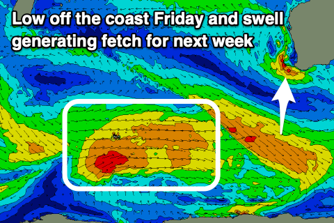
A better mid-period SW swell is due later Monday and more so Tuesday across the state, generated by a relatively weak but persistent polar front, generating a fetch of strong to near gale-force W/SW winds through our swell window over the coming days.
When the swell peaks Tuesday morning, sets to 6ft are due across the South West, 2ft+ Mandurah and 1-2ft Perth along with E/NE offshore winds. A strong will likely bring S/SW winds into the afternoon, clean again Wednesday morning as the swell eases.
Longer term there's nothing too significant on the cards until next weekend/the week after, but more on this Friday.