Large, powerful groundswells on the way

Western Australia Surf Forecast by Craig Brokensha (issued Friday 6th September)
Best Days: Sunday, Monday for experienced surfers, possibly Tuesday morning, later week and next weekend
Recap
The surf cleaned up across all locations yesterday though a little lumpy in the South West and easing from 6ft+, cleaner to the north and 2ft to occasionally 3ft.
This morning is smaller again with clean 3-4ft waves across the South West, 2ft to the north.
Today’s Forecaster Notes are brought to you by Rip Curl
This weekend and next week (Sep 7 - 13)
The easing trend will be stopped by the arrival of a new small mid-period SW swell tomorrow across the South West, though size wise there isn't expected to be much over 3-4ft+ on the magnets. Perth and Mandurah are expected to be tiny.
Winds will be offshore in Perth and Mandurah, but the South West looks dicey, especially across the southern end of the cape with onshore winds, more variable to the north.
 Sunday morning will be cleaner but a touch smaller ahead of the arrival of a large, long-period W/SW groundswell.
A moderate E'ly wind is expected ahead of sea breezes into the afternoon from the S/SW as the new swell really starts to muscle up.
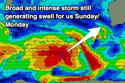
This swell is still being generated by a vigorous and slow moving polar low through the Southern Ocean, and with the low maintaining a little more strength than forecast on Wednesday, there's been a slight upgrade in the expected size, and also it will be more consistent.
The swell will build rapidly Sunday afternoon, likely reaching an easy 10ft by dark in the South West, 3ft in Mandurah and 2-3ft in Perth ahead of a peak Monday morning to 12ft+, 3-4ft and 3ft respectively.
Conditions are looking good to excellent early Monday with a dawn E/NE offshore, shifting N/NE through the morning and then NW and W/SW through the afternoon. So aim for the early.
The swell will ease into Monday afternoon, slowed Tuesday as a reinforcing SW groundswell fills in. This will be produced by a tight and late forming low south-west of us Sunday, with a fetch of severe-gale to storm-force W'ly winds generated.
 We should still see 8ft+ sets across the South West, 2-3ft in Mandurah and Perth.
Winds look a little dicey but hopefully variable across all locations through the morning, onshore into the afternoon from the N/NW.
We'll then be in for a few days of N/NW winds, Wednesday through Thursday with large levels of persistent mid-period W/SW swell.
Over greater importance is a vigorous frontal progression developing through the southern Indian Ocean next week, with a broad and elongated fetch of gale to severe-gale W/SW winds forecast to be projected towards us, dipping away to the south-east later next week.
A large W/SW groundswell is expected from this progression, building Friday afternoon and peaking Saturday morning with what looks to be light winds at this stage. Size wise we could be looking at surf to 10-12ft in the South West, 3-4ft Mandurah and 3ft Perth, but more on this Monday. Have a great weekend!