Clean easing surf, large, strong swell to follow

Western Australia Surf Forecast by Craig Brokensha (issued Wednesday 4th September)
Best Days: Thursday, Friday morning in the South West, Sunday, Monday experienced surfers
Recap
No let up in the onshore winds or large swell the past couple of days, with today still a mess across all locations.
Today’s Forecaster Notes are brought to you by Rip Curl
This week and weekend (Sep 5 - 8)
Winds will finally back off and swing offshore tomorrow morning across all locations, but the surf will be on the ease and weaker mid-period energy.
We're looking at easing sets from 5-6ft across the South West, 2ft to maybe 3ft in Mandurah and 2ft in Perth.
Friday will be smaller again and with an early E/NE offshore, NW into the afternoon. The South West will be the pick with the swell easing from 4ft on the sets, small to tiny to the north.
 Our small pulse of mid-period SW swell for Saturday is looking just that, with a poorly structured trough producing a minimal increase in swell to the 3-4ft+ range in the South West, tiny to the north. Winds look suss now with a weak front clipping the South West, bringing onshore SW winds, back E'ly on Sunday but easing in size.
Afternoon sea breezes will kick in Sunday, along with a large, long-period increase in W/SW groundswell, peaking Monday.
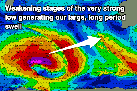
The storm generating this swell has formed south-east of South Africa, with it due to generate a broad fetch of severe-gale to storm-force W/SW winds through our swell window tomorrow, continuing east Friday but easing slowly in strength and fading Saturday.
A large, long-period and slightly inconsistent W/SW-SW groundswell is expected, arriving Sunday and building later in the day to 8ft by dark in the South West, 2ft+ in Mandurah and 2ft in Perth ahead of a peak Monday morning around 12ft, 3-4ft and 3ft respectively.
Winds on Monday will be favourable again in the morning and out of the E/NE, shifting more N/NE through the day and more variable NW into the afternoon.
The swell will ease later in the day, dropping further Tuesday though with strengthen NW winds with an approaching trough.
A couple of large reinforcing W/SW groundswells are expected in the wake of Monday's generated by back to back fronts piggy-backing up and on top of the weakening polar low.
Fetches of gale to severe-gale W/SW winds are forecast to be generated towards us, with an initial mid-period pulse later Tuesday and more so Wednesday ahead of groundswell pulses late week and on the weekend.
Winds look unfavourable and out of the north-western quadrant with each swell as the frontal progression intrudes on the state but is deflected south-east with a blocking high. This will limit surfing options, but more on this Friday.