Large easing surf with improving conditions from Thursday

Western Australia Surf Forecast by Craig Brokensha (issued Monday 2nd September)
Best Days: Thursday, early Friday in the South West, Saturday morning in the South West, Monday
Recap
Large onshore and stormy surf all weekend across the South West, half the size but still solid around Mandurah and a bit smaller again around Perth.
Today the largest of the stormy swells is filling in but with poor conditions again under strong to gale-force onshore winds.
Today’s Forecaster Notes are brought to you by Rip Curl
This week and weekend (Sep 3 - 8)
We've got a couple more days of onshore winds and large messy surf as a slow moving mid-latitude frontal progression moves across us, exiting right on Thursday.
Size wise, the swell will start to drop in size and power over the coming days, with the final front pushing towards us tomorrow and Wednesday only generating winds between 20-30kt.
This will produce moderate sized mid-period swell on Wednesday, with tomorrow seeing easing groundswell from 10-12ft in the South West, 4ft around Mandurah and 3-4ft in Perth along with strong W/SW tending W winds. Strong but easing SW winds are due into Wednesday with easing sets from 8ft in the South West, 3ft around Mandurah and 2-3ft in Perth.
 A high will finally move in on Thursday and swing winds offshore from the E/SE across the South West and E'ly further north ahead of sea breezes.
The surf may be a little lumpy early but improving through the morning but on the ease from a weakish 4-6ft across the South West, 2ft in Mandurah and 1-2ft in Perth.
Friday looks smaller again with a dawn N/NE breeze, shifting NW into the afternoon with an approaching front.
Into the weekend a small mid-period swell is expected on Saturday, generated by a weak and poorly structured trough forming south-west of us mid-week.
No major size is expected with maybe 3-5ft waves in the South West, 1-2ft Mandurah and tiny Perth but with a morning offshore ahead of sea breezes.
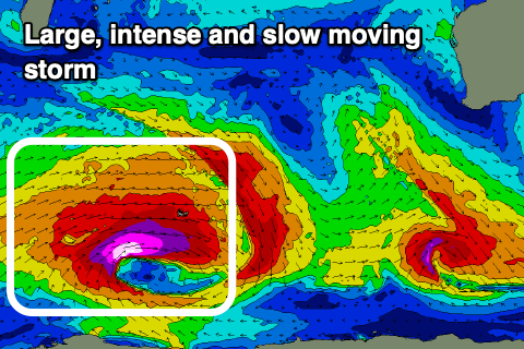
Of greater significance is a large, long-period SW groundswell for later Sunday and Monday next week. A broad and very strong polar storm is forecast to develop south-east of South Africa on Wednesday, projecting a fetch of severe-gale to storm-force W/SW winds through our swell window while slowly moving east.
The storm will be long lived and weaken south-west of us Friday evening, producing a large, long-period SW groundswell that looks to peak Monday morning around the 12ft range in the South West, 3-4ft Mandurah and 3ft Perth.
Winds look light and offshore through the morning as this stage, but we'll have a closer look at this on Wednesday.