Large and onshore period ahead

Western Australia Surf Forecast by Craig Brokensha (issued Wednesday 28th August)
Best Days: Later next week
Recap
Large and pumping waves across the coast again yesterday morning, easing in size and great again this morning before sea breezes kicked in around Mandurah and Perth, more NE around Margs.
Today’s Forecaster Notes are brought to you by Rip Curl
This week and weekend (Aug 29 – Sep 1)
Buckle up, from tomorrow we've got onshore winds and large swells until at least later next week.
A strong negative Southern Annular Mode (SAM/AAO) event will move the westerly storm track north, bringing lots of mid-latitude storms and onshore winds for our coasts and besides the coming days, the swells don't look to offer much power.
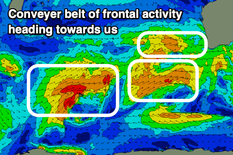 A tight and intense low formed west-southwest of us the last couple of days, aiming a fetch of severe-gale to storm-force W/SW winds in our western swell window.
A large W/SW groundswell will be seen from this low, building tomorrow and reaching 10ft on the sets across the South West, 3-4ft in Mandurah and 3ft in Perth along with dawn N tending stronger NW winds.
The swell is then expected to ease into Friday from a similar size with onshore W'ly tending NW winds.
A secondary slow moving low behind the initial system is projecting a fetch of W/SW gales towards us, producing another large W/SW groundswell to 8-10ft in the South West Saturday, 3-4ft in Mandurah and 3ft in Perth.
There'll be lots of additional windswell and mid-period swell in the mix as a strong front arrives with the swell, bringing strong but easing W tending NW winds.
Sunday will remain poor with large easing surf under NW tending W winds.
Our possible window of cleaner conditions early Monday has been removed, with another broad mid-latitude frontal system forecast to push up and into us early next week.
This will direct NW winds into all locations with another large building mid-period W/SW swell, peaking Tuesday with onshore W/SW winds.
It looks like we may see a strong high finally moving in Thursday, though squeezed by an inland surface trough resulting in fresh S/SE winds.
Size wise it looks like we'll be seeing easing mid-period SW swell from the 6ft+ range in the South West, 2ft+ Mandurah and 2ft Perth.
Following this there's plenty of more significant storm activity on the cards into early September, but more on this Friday.