Make the most of the weekend offshores

Western Australia Surf Forecast by Craig Brokensha (issued Friday 9th August)
Best Days: Saturday, early Sunday in the South West, dawn Monday selected spots
Recap
Large onshore surf across the South West, much better and cleaner further north and to 3ft+ in Mandurah and 3ft in Perth.
Today the South West has finally started to clean up with plenty of large sets in the 8ft+ range, 2-3ft in Mandurah and 2ft+ in Perth.
Today’s Forecaster Notes are brought to you by Rip Curl
This weekend and next week (Aug 10 - 16)
The slow easing trend in swell that we've seen over the last couple of days will continue into the weekend, with the surf still expected to be up around 4-6ft on the sets across the South West tomorrow morning, 2ft Mandurah and 1-2ft in Perth.
Conditions are looking great with a moderate to fresh E/NE offshore, easing and possibly tending variable into the afternoon.
Sunday will be smaller and best across the South West swell magnets with a fresh E/NE tending NE breeze, possibly more N/NE towards dark.
Our new W/SW groundswell for Monday is still on track, with an off axis mid-latitude trough/low now weakening west-southwest of us today.
This is weakening a little quicker than ideal and the swell has been downgraded a touch since Wednesday.
We should see Margs building to 4-5ft through the day and 2ft in Perth and Mandurah but with gusty early N/NE tending NW winds as the remnants move in and across us.
Tuesday will be poor as the swell eases along with strengthening W/NW winds.
Our larger W/SW groundswell for the middle of the week is still on track, though the structure of the low generating it is a little disjointed.
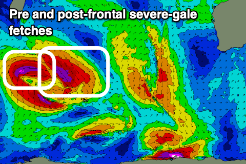 This low has developed south-east of Madagasca, generating a fetch of severe-gale pre-frontal NW winds. This will produce an initial moderate to large long-period W/SW groundswell for Tuesday afternoon though with those strong W/NW winds.
A tight post-frontal fetch of severe-gale W/SW winds are forecast, pushing in a little off axis again and weakening while broadening north of Heard Island. We'll then see the low weakening while continuing to drift south-east, giving off one final burst of severe-gale SW winds in our south-western swell window Sunday and early Monday.
We should see a larger W/SW groundswell produced by this secondary fetch, arriving through Wednesday and peaking into the afternoon to the 10ft range in the South West, 3ft in Mandurah and Perth.
Conditions will remain poor though with strengthening W/SW tedning SW winds as a small embedded low pushes in from the west.
This will also whip up an additional stormy increase in swell for Perth and Mandurah on Thursday to the 4ft range as Margs hangs around 10ft but with fresh and easing SW tending W/SW winds.
This looks to be the start of another wild and wooly run of large to extra-large swells with strong onshore winds owing to a strong and broad node of the Long Wave Trough spanning across us and the rest of the country later next week.
Therefore with this in mind make the most of the coming cleaner conditions. Have a great weekend!