Large to extra-large swells inbound, cleanest to the north

Western Australia Surf Forecast by Craig Brokensha (issued Friday 19th July)
Best Days: Protected spots Monday, Mandurah and Perth Tuesday and Wednesday morning
Recap
Variable winds most of the day across all locations as expected and a good increase in new mid-period and long-period W/SW swell yesterday to 6-8ft in the South West, 3ft+ in Mandurah and 2-3ft in Perth.
Today onshore winds have moved in across all locations but Perth early along with a further increase in size.
Today’s Forecaster Notes are brought to you by Rip Curl
This week and weekend (Jul 20 – 26)
These notes will be short as Ben's on annual leave.
There’s been no real change to the weekend outlook with an oversized and long-period W/SW groundswell due to kick later tomorrow and ease Sunday but with fresh to strong onshore SW tending W winds tomorrow, strong W tending W/SW on Sunday.
The South West looks to reach 10-12ft late Saturday and early Sunday with 3-4ft waves in Mandurah and 3ft surf in Perth.
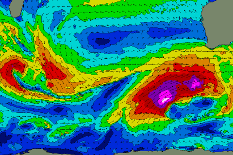 Our XL groundswell for Monday is still on track, with a significant frontal progression forecast to form south-west of us tomorrow. An initial front will generate a pre-frontal fetch of severe-gale W/NW winds, priming the ocean for a secondary stronger system to generate a fetch of storm-force W/SW tending SW winds over, in our south-western swell window.
The swell will fill in Monday and peak into the afternoon with 15-20ft waves due across the South West, 4-5ft+ in Mandurah and 4ft in Perth.
Winds will improve but remain out of the S/SW on Monday, possibly S’ly early in Mandurah and Perth. In any case protected spots will be best.
Come Tuesday winds will swing straight offshore and out of the E across Perth and Mandurah with solid easing surf from 3ft+ across the former and 4ft in Mandurah. Unfortunately Margs will see lingering onshore W/SW winds, but without too much strength.
Another weak front approaching from the south-west will keep onshore winds out of the W/NW blowing across the South West Wednesday as the swell continues to fade.
This front will generate some moderate sized SW groundswell for later week, though onshore winds will continue keep the quality low.
Longer term there’s nothing significant on the cards those conditions will improve (isn’t it always the way), but more on this Monday. Have a great weekend!