Large to extra-large swells inbound but onshore

Western Australia Surf Forecast by Craig Brokensha (issued Wedensday 17th July)
Best Days: All regions tomorrow, Perth and Mandurah Tuesday morning and protected spots in the South West, Margs Wednesday
Recap
Good conditions across all locations early yesterday with a slight drop in size from Monday, though still 6ft in the South West and the 2ft range around Mandurah and Perth. A new inconsistent W/SW groundswell built into the afternoon but with less than ideal conditions, with it easing a touch but holding size into this morning with early OK winds across all locations.
Today’s Forecaster Notes are brought to you by Rip Curl
This week and weekend (Jul 16 – 21)
These notes will be short as Ben's on annual leave.
We've got an increase in size from both the W/SW and SW tomorrow, the former being a long-range groundswell and the later a closer-range mid-period SW swell.
The models are over-forecasting and combining these two swells but we should see Margs building to 6ft to maybe 8ft through the day on the magnets, 2ft to possibly 3ft in Mandurah and 2ft in Perth.
Winds are still looking favourable across Perth and Mandurah with light morning offshores, variable into the afternoon, while Margs looks a little dicey but workable with variable winds more than likely swinging more N'ly through the day but only light.
Make the most of this window as from Friday winds will swing onshore and remain that way until around mid-next week.
A strong node of the Long Wave Trough will move across us later this week and then continue east into early next week, bringing with it a significant mid-latitude and polar frontal progression.
An initial storm forming north of Heard Island today will project a fetch of severe-gale to storm-force W/SW winds towards us over the coming days, weakening and pushing across us Friday evening.
An extra-large W/SW groundswell will be generated, kicking strongly later Saturday and then easing Sunday.
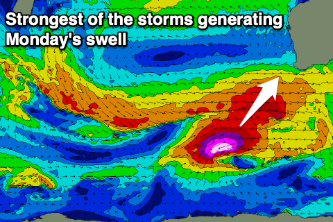 Another couple of systems look to piggy-back on the tail of this system, projecting up and towards us from the south-west, generating an even larger long-period SW groundswell for Monday.
Size wise we're looking at building surf to 10-12ft by dark across the South West Saturday, easing from a similar size Sunday, with 3-4ft waves in Mandurah and 3ft surf in Perth.
Winds will be poor and from the S/SW tending W/SW on Saturday, stronger from the W/SW on Sunday.
Monday's XXL swell looks to come in around 15ft+ at this stage across the South West but all locations will remain poor with a moderate to fresh SW breeze. A high moving slowly in on Tuesday will see winds swinging more S'ly across Margs and offshore in Perth and Mandurah with easing surf from 10-12ft in the South West, 3-4ft in Mandurah and 3ft on the sets across Perth.
By the time winds go offshore on Wednesday in the South West the surf looks to be back to the 6ft range, but we'll have a closer look at this on Friday.