Great weekend of surf across the South West

Western Australia Surf Forecast by Craig Brokensha (issued Friday 12th July)
Best Days: Saturday, Sunday, Monday and early Tuesday selected spots
Recap
Good clean conditions across Perth and Mandurah yesterday with surf to 3ft, onshore and 6-8ft across the South West, though winds did go lighter creating a few decent options in protected spots.
This morning an offshore wind is slowly cleaning up the surf with 6ft+ of swell left from yesterday, 2-3ft in Mandurah and 2ft in Perth with much better conditions.
Today’s Forecaster Notes are brought to you by Rip Curl
This weekend and next week (Jul 13 – 19)
Tomorrow looks fun across all locations with today's mix of W/SW and SW groundswell due to ease off a touch further but a reinforcing SW groundswell will slow this easing trend, generated by continued frontal activity south-west of us the last couple of days.
 The South West should continue around 5-6ft, 2ft in Mandurah and 1-2ft in Perth. Conditions will be great all day with a moderate E/NE tending variable breeze.
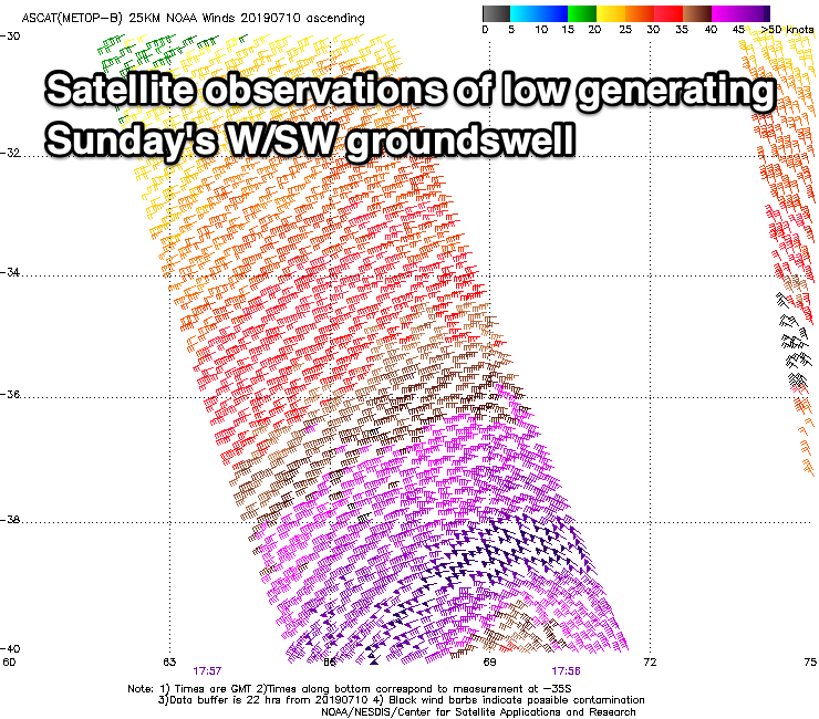
Sunday morning will be clean again with a fresher E/NE offshore, tending more NE into the afternoon as a new large long-period W/SW groundswell fills in.
This swell was generated by a tight and intense mid-latitude low that developed south-east of Madagascar earlier this week. A slither of severe-gale to storm-force W'ly winds were projected towards us, with the storm now dipping south-east towards the polar shelf but while strengthening.
This is producing an additional fetch of storm-force W/SW winds in our south-western swell window, with a secondary SW component of long-period swell due to also fill in Sunday.
Size wise, Margs should build to 6-8ft into the afternoon, 3ft on the sets in Mandurah and 2ft to possibly 3ft in Perth with the westerly direction.
A drop in size will then be seen on Monday and moderate to fresh NE tending N/NE winds will limit surfing options, even more so Tuesday with a N/NE tending NW breeze.
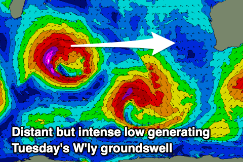 This will also spoil our secondary large, long-period W/SW groundswell that's due to fill in on Tuesday.
The swell is being generated by a bigger and slightly stronger low that's developed south-east of South Africa, but this system will weaken in our medium-range swell window.
A slightly larger W/SW groundswell should be seen, though the models aren't picking this up. I'm expecting 6-8ft+ waves to develop across the South West on Tuesday, 3ft+ in Mandurah and 2-3ft in Perth.
Unfortunately NW winds will persist as the swell eases on Wednesday, strengthening on Thursday as a larger W/SW groundswell fills in. This will be mix of long-range and inconsistent W/SW energy and close-range swell as the storm re-intensifies south-west of us mid-late week. The models diverge on how strong at this stage, so we'll have to take another look at this on Friday. In any case winds look onshore, with the Indian ocean lighting up into the longer term. Have a great weekend!