Great surf from Friday

Western Australia Surf Forecast by Craig Brokensha (issued Wednesday 10th July)
Best Days: Perth and Mandurah Thursday, all coasts Friday, Saturday, Sunday, selected spots Monday and Tuesday morning
Recap
Onshore and large surf across the South West yesterday, still onshore and back to 6-8ft today, with lumpy though OK and solid sets in Perth and Mandurah, back to 2-3ft with light onshore winds today.
Today’s Forecaster Notes are brought to you by Rip Curl
This week and weekend (Jul 11 – 14)
A new long-range and inconsistent but large W/SW groundswell is due to fill in tomorrow, generated south-east of South Africa on the weekend.
The swell is due to peak through the day to 6-8ft+ across the South West magnets, 2-3ft in Mandurah and 2ft+ in Perth. Winds still look onshore for the South West but there's the chance for more variable breezes across the northern end of the Cape early morning.
Mandurah and Perth will be clean with E/NE morning offshores, and S'ly sea breezes.
 Friday will finally see a true offshore breeze and great conditions across the South West with a straight E'ly wind, moderate in strength and variable into the afternoon. There should still be size on offer with easing sets from 6-8ft, 2-3ft in Mandurah and 2ft in Perth.
A couple of late forming fronts to our south-west will generate reinforcing SW pulses of swell for Friday/Saturday, slowing the easing trend ahead of a new long-period W/SW groundswell building Sunday.
Winds on Saturday will remain good and offshore out of the E/NE, variable into the afternoon and then fresher NE on Sunday, N/NE into the afternoon.
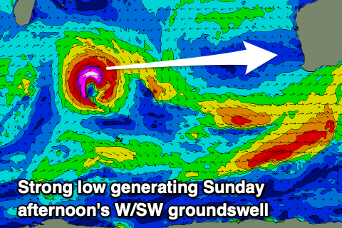
The new long-period W/SW groundswell is being generated by a small and tight low that's formed south-east of Madagascar. A slither of severe-gale to storm-force W'ly winds will be projected towards us today, weakening once north-east of the Heard Island region and dipping south-east during tomorrow afternoon.
While the fetch is small, the strength will help generate a large, long-period W/SW groundswell, building Sunday and reaching 6-8ft across the South West into the afternoon, 3ft in Mandurah and 2ft to possibly 3ft in Perth along with those NE ending N/NE winds.
Winds will hold out of the NE-N/NE on Monday as the swell eases, but another large and inconsistent W/SW groundswell is expected to take its place on Tuesday.
This will be generated by a secondary stronger and slightly bigger low forming on the tail of the first, and should produce a similar if not slightly bigger swell for Tuesday afternoon. Winds will start to take a turn for the worse though and go N to NW, but more on this Friday.