Large swells for next week as winds start to improve

Western Australia Surf Forecast by Craig Brokensha (issued Friday 5th July)
Best Days: Perth and Mandurah Saturday and Monday mornings, Tuesday morning all locations, Wednesday morning Perth and Mandurah, Thursday and Friday all locations
Recap
Average early yesterday across the South West but improving as winds tended variable and the swell built, while to the north there were also varying conditions through the day as a trough moved through.
Today a large new SW groundswell has filled in but with poor conditions in the South West and 8ft+ sets, 3-4ft and lumpy and Mandurah with lumpy 3ft waves in Perth.
Today’s Forecaster Notes are brought to you by Rip Curl
This weekend and next week (Jul 6 – 12)
Today's large SW groundswell will ease into tomorrow and conditions will remain poor in the South West with a strong but easing W/SW breeze. Perth and Mandurah look better with early variable tending NE winds and easing 2-3ft sets.
Sunday will be smaller and conditions bumpy early in Perth and Mandurah with a N'ly breeze, shifting more N/NW through the day. Margs looks poor with stronger N/NW winds all day.
Our large long-period W/SW groundswell for Monday/Tuesday is just that but the size has been downgraded slightly, as is the arrival time.
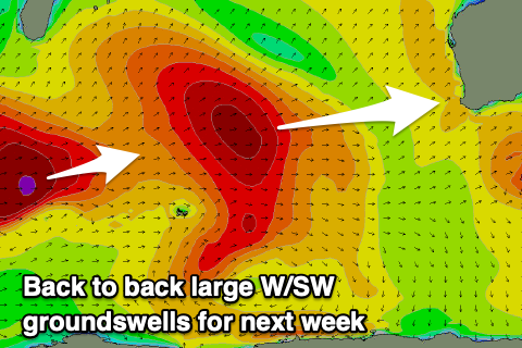 A very intense low forming south-east of South Africa this week has projected a slow moving fetch of severe-gale to storm-force W/SW winds towards us. The storm is now weakening north-east of Heard Island and will continue to break down into the weekend.
A large and long-period W/SW groundswell will arrive from this source Monday afternoon, building to 10-12ft by dark, and then easing from a similar size on Tuesday morning. Mandurah should see 3-4ft sets, with 3ft waves in Perth.
Winds will remain onshore out of the W/SW-SW across the South West Monday with better light SE breezes to the north, but onshore and sea breezey when the swell proper builds.
Tuesday morning looks great with the large easing swell and SE offshores in Perth and Mandurah, lighter S/SE across Margs, favouring protected spots.
Wednesday looks dicey again across the South West as onshore winds kick back in, cleaner to the north with morning E/NE winds and a further drop in swell.
A new inconsistent and large W/SW groundswell is due Thursday, generated by another strong storm developing south-east of South Africa, but this won't have the scope or intensity as the last and will weaken quicker. A fetch of severe-gale to storm-force W'ly winds will be projected through our far western swell window before the storm weakens and dips east-southeast around Heard Island on the weekend.
This swell should kick the South West back to an inconsistent 8ft+ through Thursday with 2-3ft sets in Mandurah and a touch less size across Perth.
Winds look more favourable across the South West and light offshore out of the E/SE, though we'll have to confirm this on Monday. Friday looks great as well as the swell slowly eases, with the next increase in size seen early the next week as winds take a north-easterly turn. More on this Monday though, have a great weekend!