Large to extra-large swells but with dicey winds

Western Australia Surf Forecast by Craig Brokensha (issued Wednesday 3rd July)
Best Days: Mandurah late morning tomorrow, Perth and Mandurah Saturday morning, Monday and Tuesday morning
Recap
Improving conditions across the South West yesterday with variable winds and large easing 10-12ft surf, better in Perth and Mandurah with easing 3-4ft and 3ft+ waves respectively.
This morning the swell has eased further and cleaned right up across the South West with a fresh E/NE offshore and easing 6-8ft waves. Perth and Mandurah were also great with easing 2-3ft sets.
Today’s Forecaster Notes are brought to you by Rip Curl
This week and next week (Jul 4 – 12)
This morning is probably the last time we'll see an offshore wind across the South West for a while, with conditions due to deteriorate from tomorrow and remain poor until later next week.
The Long Wave Trough will move across us later this week but in a weakened form and with this it will direct frontal systems up and across us though without much strength, but enough to create average conditions.
 These fronts will in their earlier life be much stronger storms in the southern Indian Ocean, producing large pulses of groundswell.
The first is due on Friday, but ahead of this tomorrow we'll be looking at smaller waves across all locations as a W'ly change moves through at dawn in the South West, with strong N/NE winds to the north, tending variable into the afternoon ahead of the change later. With this in mind it might be worth checking the Mandurah beaches later morning as winds ease for a small 2ft'er.
The SW groundswell on Friday should build to 8ft to occasionally 10ft on the sets across the South West into the afternoon with 3ft sets in Mandurah and Perth but with moderate to fresh S/SW winds across all locations.
Saturday will see the swell easing with SW tending W/NW winds in the South West, and variable tending NE and then NW winds to the north. Perth and Mandurah look to ease from 2-3ft, smaller Sunday and with poor and strengthening NW tending W/NW winds.
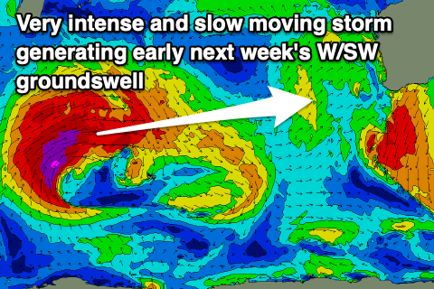
An extra-large long-period W/SW groundswell is expected to fill in on Monday, generated by an intense low that's forecast to form south-east of South Africa tomorrow.
A prolonged fetch of severe-gale to storm-force W/SW winds will be projected towards us from tomorrow through until Saturday morning when the low finally starts breaking down west-southwest of us.
The swell is expected to arrive Monday and build rapidly into the afternoon and evening, peaking overnight and easing Tuesday.
Margs looks to reach 12ft+ across most breaks with 15ft sets on the magnets, 3-4ft+ in Mandurah and 3-4ft in Perth by close of play. Winds may become variable Monday morning in the South West, with light E/SE offshore winds to the north, sea breezey into the afternoon. The swell should start to ease Tuesday but with N/NW winds in the South West owing to an approaching trough, NE early to the north.
A secondary pulse of smaller W/SW groundswell is due later week with an improvement in winds, but more on this in Friday's update.