Generally poor onshore weekend, XL SW groundswell for early next week

Western Australia Surf Forecast by Craig Brokensha (issued Friday 28th June)
Best Days: Perth and Mandurah early tomorrow and Monday morning, all locations Tuesday and Wednesday
Recap
XL stormy surf across the South West the last two days with strong to gale-force onshore winds, better for protected spots today. Mandurah and Perth were poor yesterday but this morning a variable tending light offshore wind has created great surf with 3-5ft and 3-4ft surf respectively.
Today’s Forecaster Notes are brought to you by Rip Curl
This weekend and next week (Jun 29 – Jul 5)
We'll see the XL swell continuing to ease across all locations tomorrow and with onshore winds across the South West out of the W/NW tending NW, strengthening through the day.
Perth and Mandurah will offer cleaner conditions but not as good as this morning with a moderate N/NE'ly and easing sets from 3ft in Mandurah, 2-3ft Perth. Winds will shift N/NW through the morning so aim for the early.
Sunday will be poor everywhere with onshore W/NW winds across the South West and NW tending W/NW winds to the north.
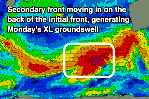 We'll likely see some new SW swell building through the day Sunday, ahead of an XXL long-period SW groundswell on Monday. The frontal progression generating these swells has already developed in the Heard Island region. A fetch of gale to severe-gale W/SW winds are being generated and will project up towards us over the coming 24 hours, followed by a slightly stronger secondary front piggy-backing up on top the large, active sea state tomorrow.
The swell is due to fill in Monday and peak to 12-15ft+ across the South West, 4-5ft in Mandurah and 3-4ft in Perth but with poor onshore SW winds. There's a high chance Perth and Mandurah will see more variable winds from the S'th early Monday, creating cleaner conditions.
Tuesday still looks to be the day to surf as winds shift E/NE across Perth and Mandurah but the South West looks a little dicey with a variable N/NE breeze.
There'll be plenty of size left in the mix with easing 10-12ft+ waves across the South West, 4ft in Mandurah and 3ft to maybe 4ft in Perth.
NE winds will hold most of Wednesday, tending N/NE later as the swell continues to ease, strong to gale-force N/NW tending W/NW on Thursday.
This strengthening onshore wind will be related to a trough moving in from the west, deepening to a mid-latitude right off our coast late week. Both models have this and we'll see a large to XL swell developing with strong to gale-force onshore winds late week. More on this Monday, have a great weekend!