XXL swell inbound but with poor winds

Western Australia Surf Forecast by Craig Brokensha (issued Monday 24th June)
Best Days: Perth and Mandurah early tomorrow morning, possibly Friday morning but more so Saturday morning
Recap
Average conditions with varying onshore winds across the South West on Saturday as Friday's large swell eased, smaller and still onshore Sunday.
Mandurah and Perth saw N/NE winds and easing surf for the desperate on Saturday, cleaner Sunday morning with a reinforcing swell to 2-3ft across both regions.
Today a large mid-period W/SW swell has filled in with average conditions continuing across the South West, solid in Perth and Mandurah but onshore, cleaner into this afternoon as the swell sorted itself out more.
Today’s Forecaster Notes are brought to you by Rip Curl
This week and weekend (Jun 25 - 30)
We'll see today's mid-period W/SW swell easing through tomorrow but the South West will remain poor with a fresh and gusty N/NW onshore wind. Perth and Mandurah are looking cleaner though not great with an early N/NE breeze and easing surf from 3ft around Mandurah and 2ft in Perth.
Our XXL long-period W/SW groundswell for the middle of the week and associated onshore winds are still on track, though there's been a slight downgrade in the expected size.
Over the weekend a vast fetch of severe-gale W/SW winds setup in the southern Indian Ocean, and we'll see a secondary intensification of severe-gale winds sling shotting up towards us, on top the active sea state this evening and tomorrow.
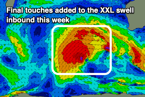 What we'll see is in initial large increase in W/SW groundswell on Wednesday, with the XXL energy filling in Thursday and peaking through the day.
Margs should build to an easy 12ft+ through Wednesday, with 3-5ft waves in Mandurah, 3-4ft in Perth but with strong N/NW tending near gale-force W/SW winds into the afternoon with a change.
Thursday's swell looks to come in at 15ft+ across the South West, 4-6ft in Mandurah and 4ft+ in Perth but with strong and persistent onshore W'ly winds, leaving no decent options at all.
Unfortunately a strong high that was forecast to move in late week now looks to sit further north and this will result in onshore SW winds persisting across the South West Friday as the XXL swell eases, possibly S/SE further north but we'll review this on Wednesday.
Saturday should see a morning E/NE offshore in Perth and Mandurah with a bit of size persisting, easing from 3ft+ in Mandurah and 2-3ft in Perth. Margs will see N-NW winds, but there may be a window of early N/NE winds for desperate surfers, though options will be limited.
Longer term we've got a large SW groundswell on the cards for early next week and with lighter local winds.
The Long Wave Trough will move slowly east over the weekend, directing a flurry of significant frontal systems up and through our south-western swell window, onwards through the Bight on the weekend and early next week.
This will generate back to back large to extra-large pulses of SW groundswell for early next week with more favourable winds. More on this Wednesday though.