Large N/NW swell ahead of XXL stormy surf

Western Australia Surf Forecast by Craig Brokensha (issued Wednesday 5th June)
Best Days: Friday morning selected spots
Recap
Yesterday's large new W/SW groundswell came in on forecast across the South West, clean early and becoming increasingly bumpy and peaky into the afternoon with strengthening N/NE winds. Mandurah was a little smaller than expected and around 2ft, with 1-2ft waves in Perth.
Today the swell has eased and winds are stronger creating average conditions in the South West, small to tiny in Mandurah and Perth.
Today’s Forecaster Notes are brought to you by Rip Curl
This week and weekend (Jun 6 - 9)
We've got a poor and onshore run of surf over the coming period with funky weather as a strong node of the Long Wave Trough focusses across us, but cold fronts spawn off into cut-off lows.
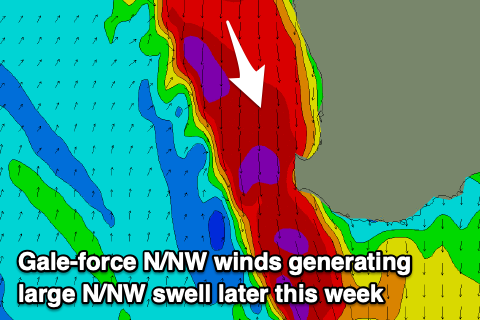 Swell wise, there's nothing of significance due into the end of the week besides building levels of N/NW windswell as a deep trough moves in from the west, squeezing a strong high in the Bight.
Strengthening N/NE tending N winds tomorrow are expected to reach gale-force into the afternoon, kicking up large stormy waves across Margs into the evening, smaller around Perth and Mandurah.
A strong W/SW change on Friday morning may provide some interesting options in selected spots as the N/NW swell rapidly eases from 6ft to possibly 8ft at north swell magnets, much smaller elsewhere.
Winds will remain onshore out of the N/NW tending W on Saturday as a vigorous polar front come mid-latitude low projects up towards us but then stalls west of us on Saturday evening.
There'll be nowhere to recommend on Saturday, but come Sunday we'll see a mix of large long-period SW groundswell and extra-large stormy W/SW swell building on the coast as the mid-latitude low pushes in across us, bringing gale to storm-force W/SW winds, slamming right into the south-west of the state.
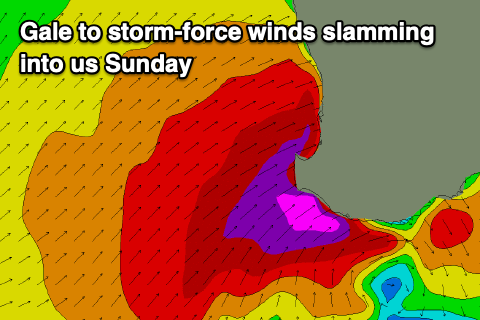 The surf will jump rapidly and conditions on the coast will be horrendous with the size likely to reach upwards of 15-20ft in the South West, 6ft+ in Mandurah and 4-6ft in Perth but with those gale to storm-force winds, abating through the day.
A secondary mid-latitude low firing up behind this initial system as it moves east will drift in from the south-west, bringing another increase in XXL stormy swell on Monday with gale to severe-gale SW winds.
The models diverge regarding the track and strength of this system but either way we're looking at very large and stormy surf for a number of days early next week. Check back here on Wednesday for more about this.