Good swell tomorrow but with northerly winds, poor thereafter

Western Australia Surf Forecast by Craig Brokensha (issued Monday 3rd June)
Best Days: Selected spots tomorrow and early Wednesday, Friday morning selected spots with the N/NW windswell
Recap
Pumping waves across all locations on Saturday with a large new W'ly groundswell and offshore winds, remaining favourable into the afternoon with a drop in swell Sunday but still good waves across selected breaks.
Today the swell was smaller again with morning offshore winds and we should see some new mid-period W/SW swell showing this afternoon as winds persist from the N/NE.
Today’s Forecaster Notes are brought to you by Rip Curl
This week and weekend (Jun 4 - 9)
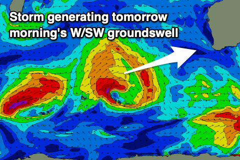 Later today's increase in mid-period W/SW swell will be followed by a larger and stronger SW groundswell tomorrow morning, produced by a strong frontal system dipping south-east through our swell window over the weekend. The fetch wasn't great but it was sustained with gale to severe-gale W/SW winds projected through our swell window while dipping slowly east-southeast, generating a moderate to large SW groundswell.
Margs should come in at 6-8ft, with possibly the rare bigger cleanup, easing through the day, with 2-3ft sets in Mandurah and 2ft+ waves in Perth.
Winds will be an issue though and moderate to fresh from the N/NE (NE further north in Perth and Mandurah), strengthening into the afternoon across the South West.
Wednesday will be poor as stronger N/NE winds develop across all locations, swinging N into the afternoon as Tuesday's swell continues to ease along with a building N'ly windswell.
Winds will become even stronger into Thursday as a very deep trough moves in closer to us, with the N/NW windswell due to become sizey across the South West, with a W/SW change due to move in Friday morning.
There'll be only one or two options to surf with the easing N/NW windswell and W/SW change on Friday morning before it fades through the day.
As talked about last update, following this trough we'll see a flurry of vigorous frontal systems projecting up through our south-western swell window under the influence of a strong node of the Long Wave Trough moving across us.
At this stage we're looking at large to extra-large and onshore swells, but we'll have to confirm this on Wednesday.