Great couple of days ahead, large pumping swell Saturday

Western Australia Surf Forecast by Craig Brokensha (issued Monday 27th May)
Best Days: Tuesday and Wednesday in the South West, desperate surfers Friday, Saturday all locations
Recap
Good peaky and improving waves across the South West Saturday as winds shifted more offshore along with easing 3-5ft of SW swell. Sunday was a touch smaller again but nice and clean, while around Mandurah the surf was clean and to 2ft Saturday, tiny Sunday.
Today the surf started a little slow in the South West but a new inconsistent SW groundswell has filled in and is providing a bit more size than expected. Most reefs are 4-6ft and clean, with a couple of 8ft bombs as shown in the screengrabs below. Mandurah and Perth have increased a touch but are mostly tiny.


Today’s Forecaster Notes are brought to you by Rip Curl
This week and weekend (May 28 – Jun 2)
Today's new long-period SW groundswell which has over-performed in the South West is due to ease through tomorrow, but we've now got a new long-period S/SW groundswell on the cards for tomorrow afternoon and Wednesday morning.
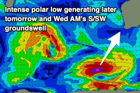 A very intense polar low formed a little earlier than forecast on Friday last week, producing a tight and strong fetch of severe-gale to storm-force W/SW winds in our southern swell window.
This swell should build tomorrow afternoon, peak overnight and ease through Wednesday.
Size wise tomorrow should start around 4-5ft on the sets, with the new groundswell kicking to 6ft through the afternoon, if not for the odd bigger clean up later, while Mandurah and Perth ease from 1-1.5ft.
Winds will be great all day, moderate to fresh and fairly straight from the E-E/SE, while Wednesday looks great as well with a moderate to fresh E/NE offshore, holding all day. This will be along with easing sets from 4-6ft across South West swell magnets, tiny to the north.
Thursday is looking average as the size becomes small in the South West and an approaching mid-latitude front brings strong N/NE tending N/NW winds.
Our new long-period W/SW groundswell from the intense low forming over near Heard Island has changed a little, with the storm-force fetch around the core of the low not quite developing, instead replaced by a short burst of severe-gale W/SW winds in our western swell window last night and today.
We'll see a short burst of W/SW groundswell from this source, kicking later Thursday and peaking Friday to 5-6ft or so across Margs, maybe 1ft to occasionally 2ft in Perth and Mandurah.
Winds look as if they'll remain onshore in the wake of a change Thursday evening with a moderate S/SW'ly, tending more S/SE through the afternoon as a high moves in from the west. Perth and Mandurah should see S/SE winds from the get go.
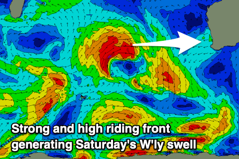 Of greater importance is a large new W'ly groundswell due Saturday, produced by a strong mid-latitude front spawning off the back of the low and tracking quite north, directing a fetch of W/SW gales through our western swell window tomorrow and Wednesday before weakening into the afternoon - then tracking south-east on approach to us Thursday.
A large W'ly groundswell will be generated, arriving overnight Friday and peaking Saturday morning to the 10ft range on the sets in the South West, 3-4ft in Perth and Mandurah.
Winds will be excellent owing to the high moving in Friday, continuing further east on Saturday directing straight and persistent E/SE tending E/NE winds across the coast.
The swell will ease slowly on Sunday but another approaching front will quickly swing winds around to the N/NE tending N/NW, creating poor conditions.
Therefore make the most of Saturday.
This front will generate another large W/SW groundswell for early next week that at this stage looks similar if not a tad bigger than Saturday's though with dicey NW winds. We'll have a closer look at this Wednesday though.
Comments
Looks like the new swell is starting to show. There's a guy at the bottom of the peak first shot..