Large surf on the way, with slightly tricky winds

Western Australia Surf Forecast by Craig Brokensha (issued Wednesday 8th May)
Best Days: All coasts tomorrow morning, Friday morning, Saturday morning and early Sunday, Margs and Mandurah Monday morning
Recap
Large levels of W/SW groundswell yesterday, pumping around Mandurah and Perth to 3-5ft and 3-4ft respectively, with the South West bumpy and best in protected spots. This morning the swell has eased off and winds have remained average across the South West, much better and clean to 2-3ft in Perth and Mandurah.
Today’s Forecaster Notes are brought to you by Rip Curl
This week and weekend (May 9 – 12)
The surf will continue to drop in size tomorrow morning ahead of a new large and late kick in inconsistent W/SW groundswell. The morning looks to be smaller and back to 4-5ft across the South West with much cleaner conditions under an E/NE offshore, and weak afternoon sea breezes. Mandurah will be smaller and back to 2ft on the sets, 1-2ft in Perth.
The new inconsistent W/SW groundswell should kick to 6-8ft by dark across the South West and only maintain 2ft surf further north, with the best pulse of swell due on Friday offering infrequent but large 10-12ft sets on the South West swell magnets, 3-4ft in Mandurah and 3ft in Perth.
 Winds are still looking a little dicey, taking an NE bias through the morning, tending more N/NE later morning, N'th into the afternoon and then tending variable on dark, with sea breezes to the north.
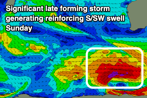
Friday's swell will continue to ease on Saturday, but a reinforcing pulse of long-period S/SW groundswell is now due, produced by a significant storm developing east of Heard Island today.
A fetch of severe-gale to storm-force W'ly winds will be generated late in our swell window, with the swell impacting Margs mostly.
We should see the South West holding around 6-8ft all day, if not for the odd sneaky bigger one into the afternoon, with 2-3ft sets in Mandurah, smaller and 2ft in Perth. Winds are expected to play our similar to Friday with a morning NE breeze, shifting N/NE soon after and lighter N/NW into the afternoon.
Sunday should be clean again with an early E/NE-NE offshore as the S/SW groundswell eases, but a trough will move through late morning bringing a weak onshore change.
A new SW groundswell should be seen building Monday, produced by a small and late forming mid-latitude low south-west of us on the weekend. A quick burst of W/NW gales should generate a fun kick in size to 6ft across the South West, 2ft in Mandurah and 1-2ft in Perth along with a light morning E/SE offshore.
Longer term winds look favourable each morning next week with moderate amounts of swell ahead of a larger increase later week. More on this Friday.
Comments
The first of our long-range W/SW groundswells has hit. Cape Naturaliste buoy is at 18s..