Poor weekend, then great surf developing next week

Western Australia Surf Forecast by Craig Brokensha (issued Friday 3rd May)
Best Days: Protected spots later Monday, Tuesday Perth and Mandurah, protected spots to the south, Wednesday morning, Thursday, Friday
Recap
Great conditions and fun leftover surf yesterday in the South West to 4ft, tiny further north and to 1-1.5ft.
Today was clean again but inconsistent with a long-range SW groundswell to 3-4ft in the South West, tiny to the north.
Today’s Forecaster Notes are brought to you by Rip Curl
This weekend and next week (May 4 – 10)
As touched on the last couple of updates, the weekend will be poor as an approaching mid-latitude front projects a fetch of strong W/SW winds towards us today, bringing onshore N/NW tending W/NW winds and a late kick in good W'ly swell, peaking Sunday to 2-3ft in Perth and Mandurah and 4-5ft+ across the South West.
Conditions will remain poor on Sunday though with a strengthening N/NW tending NW breeze.
This will be associated with a secondary stronger polar front pushing up and towards us a mid-latitude storm.
A fetch of W/SW gales will be projected towards us from today through the weekend, weakening on approach Sunday, generating a large and powerful W/SW groundswell for later Monday and Tuesday morning.
 Ahead of the groundswell localised windswell will take its place, building Monday and becoming large with stormy 6-8ft surf in the South West through the morning, 2-3ft in Perth and Mandurah.
The groundswell should kick wave heights larger later, peaking Tuesday morning to 10-12ft, 3-5ft in Mandurah and 3-4ft in Perth.
Conditions on Monday will remain poor with strong but easing SW tending S/SW winds.
Tuesday looks to remain onshore in the South West with a moderate S/SW breeze, pumping to the north with a light E/NE offshore.
Wednesday looks better in the South West as winds tend more S/SE, though it'll be best in protected spots, with better SE/ESE winds further north in Mandurah and Perth.
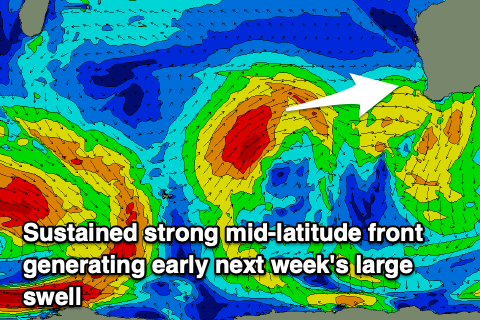
As touched on also in the last update, a large long-period W/SW groundswell is due later week, produced by a significant storm that's already formed south of South Africa.
A great fetch of severe-gale to storm-force W'ly winds are being generated in our far far swell window, with the low due to broaden and move slowly east, remaining in our far swell window on the weekend while generating severe-gale W/SW winds.
The low is expected to continue ease before weakening around Heard Island early next week.
What we'll see is two long-period groundswells, the first and most inconsistent and smallest, from the initial fetch today, arriving Thursday afternoon and building later, with a secondary more consistent swell for Friday.
Size wise Margs should build to an inconsistent 6-8ft by dark on Thursday, 2ft on the sets in Mandurah and Perth, with Friday coming in at 10-12ft, 3-4ft and 2-3ft respectively.
Winds are looking favourable and offshore out of the E/SE tending SE Thursday, then E/NE winds on Friday. We'll confirm this on Monday. Have a great weekend!
Comments
Pumping with E/NE winds, very uplifting. I,ll be home soon.