Large to very large swells inbound

Western Australia Surf Forecast by Craig Brokensha (issued Wednesday 17th April)
Best Days: Perth and Mandurah tomorrow morning, dawn around Margs, protected spots later Friday, Saturday all locations (protected spots in the South West), early Sunday, Tuesday and Wednesday
Recap
XXL stormy onshore surf across the South West yesterday, biggest into the afternoon while Mandurah and Perth offered solid bumpy and choppy waves with strong but easing onshore winds.
This morning was pumping around Mandurah and Perth with a great offshore wind, 3-5ft waves around the former and 3-4ft around the later. Margs was best in protected locations with lighter and more variable winds.
Today’s Forecaster Notes are brought to you by Rip Curl
This week and weekend (Apr 18 - 21)
The current swell will ease off gradually through this afternoon, dropping back further from the 6-8ft range in the South West tomorrow morning, 2-3ft in Mandurah and 2ft+ in Perth.
Winds are looking a little dicey now and only NE for a very short period across the South West at dawn tomorrow morning, better and E/NE further north, with all coasts shifting NW through the day.
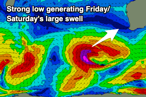 This onshore wind change will be linked to a severe low projecting up and towards us, splitting apart and forming more into a frontal system as it moves across the South West Friday.
The low is currently projecting a fetch of severe-gale to storm-force W/SW to S/SW winds through our south-western swell window, but as it starts to split, an elongated fetch of S/SW gales will be drawn out from the polar shelf up and into us.
What we're expected to see is another significant and large long-period SW groundswell for Friday, with it easing slowly through Saturday and Sunday.
Size wise, Margs looks to now reach 12ft+ into the afternoon with 3-4ft waves in Mandurah and 3ft in Perth but with strong SW winds
The swell is expected to ease slowly Saturday from a similar size and winds will remain average in the South West and out of the S/SW, best in protected spots and S/SE later in the day, while Mandurah and Perth should offer morning S/SE-SE breeze.
Sunday will offer another small window of clean conditions with an E/NE offshore as the swell continues to ease, followed by N/NW winds into the afternoon.
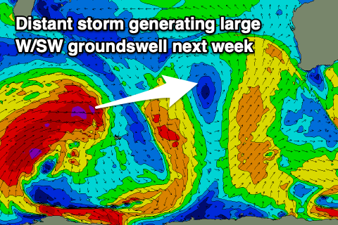 Longer term a new large long-period but less consistent W/SW groundswell is due Tuesday, produced by a very broad and significant storm developing south-east of South Africa.
An elongated fetch of severe-gale W/SW winds will move slowly through our far swell window, progressing east across the Heard Island region while weakening a touch.
The storm will then continue east in a much weaker state towards us early next week, clipping the state on Monday.
This will buffer the swell decay, but size wise we should see the long-period W/SW groundswell arriving Tuesday morning and building to what looks to be 8-10ft by later in the day in the South West, 2-3ft in Mandurah and 2ft in Perth. Winds looks OK and out of the S/SE Tuesday with better E/SE winds as the swell eases Wednesday. More on this in Friday's update though.