Large swell for the weekend, active into early next week as well

Western Australia Surf Forecast by Craig Brokensha (issued Friday 5th April)
Best Days: Margs tomorrow morning, all locations Sunday and Monday, Margs Tuesday, Friday
Recap
Building windy and onshore surf through yesterday but without too much quality or power. The swell has cleaned up a bit this morning with OK 4-6ft waves for keen surfers this morning across the South West, fun across Mandurah and Perth and to 2ft, the best it's been in a while.
Today’s Forecaster Notes are brought to you by Rip Curl
This weekend and next week (Apr 6 - 12)
Today's mid-period S/SW swell will fade through tomorrow, but some longer-range and better period SW energy should fill in, with easing sets from 4-5ft across the South West, 1-1.5ft in Mandurah and 1ft+ in Perth. Conditions will be nice and clean with a light SE-E/SE offshore across most breaks giving into SW sea breezes.
Looking at our large long-period S/SW groundswell for Sunday and it's on track, with a strong and broad polar low currently sitting south-west of us.
This low formed mid-week and has been producing a great slow moving fetch of severe-gale to storm-force W/SW winds through our south-western swell window and will continue to generate a broad fetch of severe-gale W/SW winds through our southern swell window as it pushes up slowly towards the Bight tomorrow.
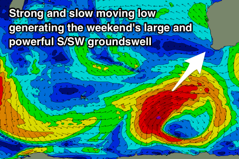 There's been no change to the expected size with the South West due to build to a large and powerful 10-12ft on the magnets, 2-3ft in Mandurah and Perth.
Winds will be fresh but favourable and out of the SE, tending S-S/SE through the afternoon.
The swell will ease through Monday with an excellent E/SE offshore wind, with dropping sets from 8ft or so across the South West, 2ft in Mandurah and Perth.
The secondary stronger system will form just a touch too late to generate any major large backup swell, but in saying that the South West will still pump. A fetch of severe-gale to storm-force SW winds will be produced just within our southern swell window, with the swell arriving Tuesday morning keeping magnets exposed to the S'ly swell around 6ft to occasionally 8ft.
Mandurah looks to be small and maybe 1-2ft, with Perth tiny. An E/NE offshore should great great conditions, tending variable ahead of sea breezes.
 From here the swell will continue to ease in size and winds will go funky and out of the S'th in the wake of a weak trough.
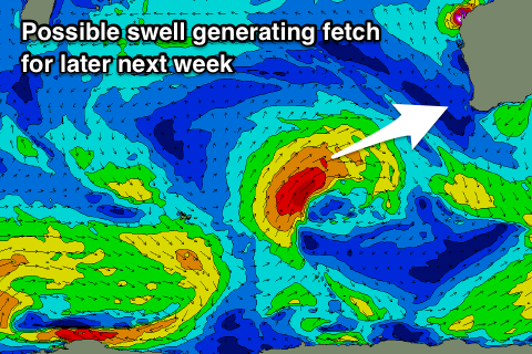
Our next swell looks to arrive later in the week, large and out of the W/SW as a polar front projects up towards us through the middle of next week while generating a fetch of gale to severe-gale W/SW winds.
The swell is due to build Friday with what looks to be offshore E/SE winds, though we'll have to have a closer look at this on Monday. Have a great weekend!