Mixed conditions to come, best from the weekend

Western Australia Surf Forecast by Craig Brokensha (issued Monday 1st April)
Best Days: Protected spots in the South West tomorrow, more so Wednesday morning, Saturday morning, Sunday, Monday, Tuesday
Recap
Small though clean and fun 2-3ft+ waves across the South West magnets Saturday morning, clean again Sunday but a touch smaller. Perth and Mandurah were smooth but tiny and unsurfable.
Today a small lift in long-period and inconsistent SW groundswell has boosted the South West to 3-4ft while Perth and Mandurah have remained tiny.
Today’s Forecaster Notes are brought to you by Rip Curl
This week and weekend (Apr 2 - 7)
The surf should increase a little more in size tomorrow as a mid-period SW swell fills in, generated by a small tight low over the weekend. Surf in the 4-5ft range is expected across Margs swell magnets on the sets, possibly 1-1.5ft in Mandurah and 1ft in Perth.
Winds will be OK but not great and moderate from the S/SE-SE through the morning, fresher into the afternoon and tending S/SW north of the Cape.
 The swell will ease through the day and our new S/SW groundswell for Wednesday looks to be more so mid-period S/SW energy and from a weak front that's currently weakening south-west of us.
Surf to 3-4ft or so is only due on Wednesday but conditions will be good with an E'ly offshore, tending E/NE ahead of afternoon sea breezes.
As touched on in Friday's update, the longer term outlook is more promising as a strong node of the Long Wave Trough develops just over the south of us and then moves off to the east through the weekend and early next week.
As the node strengthens we'll see a weak polar front projected up and into us, forming a mid-latitude low that will moved off quickly to the east. With it a stormy though short-lived increase in weak mid-period SW tending S/SW swell is expected late Thursday, easing Friday.
 Margs looks to ease from 4-6ft, 2ft in Mandurah and 1-2ft in Perth along with S/SE winds. Saturday should be cleaner as some less consistent long-period SW energy fills in from the earlier stages of the polar front. Margs will be the pick with clean easing 4-5ft sets.
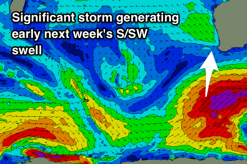
Of greater importance is the stronger frontal activity forming as the node moves towards Victoria. Persistent and strengthening storms in our southern swell window are expected, the first forming later this week as a polar low and generating a long-period S/SW groundswell for Sunday which should kick to an easy 8ft through the afternoon in the South West, 2-3ft in Mandurah and 2ft in Perth.
A morning E'ly offshore will give into afternoon sea breezes, clean again as it eases Monday morning.
A much broader and significant polar fetch forming south of us over the weekend should then generate another larger long-period S/SW groundswell for later Monday but more so Tuesday with great offshore E/NE winds. Size wise this looks to come in at 8-10ft across the South West, but we'll have a closer look at this Wednesday.
Comments
Glad you’re back Craig. You’re MY MAN
Thanks B!