Slow weekend with large swells next week

Western Australia Surf Forecast by Craig Brokensha (issued Friday 8th March)
Best Days: Protected spots Monday, Tuesday morning, Wednesday morning protected spots, Thursday morning
Recap
Variable winds and great conditions across the South West all day yesterday with a smaller 3-4ft of groundswell, tiny in Mandurah and Perth.
Today the swell is a bit smaller again and the winds OK but not perfect.
Today’s Forecaster Notes are brought to you by Rip Curl
This weekend and next week (Mar 9 - 14)
This weekend is not great at all with the surf remaining on the small to tiny side until later Sunday.
A morning variable breeze tomorrow should creating clean conditions but I wouldn't expect much over 2-3ft across the South West magnets, tiny to flat to the north.
A touch more size is likely Sunday morning with an increase in mid-period swell with a SE wind, ahead of a larger long-period SW groundswell into the afternoon and Monday morning.
 This swell has and is still being generated by a strong polar front that's just east of the Heard Island region, generating a fetch of gale to severe-gale W'ly winds. We'll see this front project north-east towards us while weakening today and tomorrow, passing under us tomorrow evening.
The groundswell should kick strongly Sunday afternoon and reach at least 6ft+ in the South West and 2ft in Mandurah but with sea breezes, peaking Monday morning to 8ft+ and 2ft to possibly 3ft respectively with 2ft sets in Perth.
Winds will swing a little less favourably to the S/SE for Monday, stronger into the afternoon across the South West and sea breezey to the north, favouring protected spots.
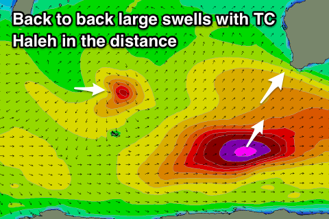
Our secondary larger long-period S/SW groundswell for Tuesday is still on track, with a secondary vigorous polar front due to form east of Heard Island tomorrow afternoon.
A fetch of storm-force W/SW winds will be generated in our southern swell window tomorrow evening and Sunday, moving out of our swell window Monday morning.
With the storm acting on the back of the front before we'll see a large and powerful S/SW groundswell that's due to arrive in the early hours of Tuesday morning and peak through the morning to 10-12ft across the South West, 2-3ft in Mandurah and 2ft in Perth.
Conditions look excellent with an E/SE offshore, sea breezey into the afternoon.
The swell will ease later in the day and more so Wednesday with a shift back to S/SE winds.
Tropical Cyclone Haleh which is currently east-southeast of Madagascar will be absorbed into the westerly storm track and generate a small fetch of strong to gale-force W/NW-NW winds in our western and then south-western swell window.
While not ideally aligned it should still produce a small spike in swell for Thursday to 4-6ft across the South West, 2ft in Mandurah and 1-2ft in Perth along with an E/SE offshore.
Following this we may see a new SW groundswell for next weekend, but more on this Monday. Have a great weekend!
Comments
So I take it the swell coming from Tropical Cyclone Haleh will be a Sw direction swell.. or will it be from a W direction?
A tricky one direction wise but W/SW tending SW.
Ain't small in Margs this AM.


WA Forecaster notes will be updated Tues/Thurs/Sun for the next few weeks while Craig is away. Apologies for the inconvenience.
Jesus.


Oh, man.
One set at the Boatramp, a few minutes ago.


Nice sequence. Not bad for a surfcam, eh? Hang on, I gotta go - Ted Grambeau's knocking on the door.


For size.


Epic, simply epic.


Fucken oath it is
Take a good look at the size of this inside bowl (I didn't get frames from the main peak, but it was huge). Right click and open image in new tab to see just how incredible this is.

And here's a big outside bomb from a little while ago.


Much smaller at Yalls (mainly due to S/SW swell direction) but jeez it's purdy.

Looks like a fun day out there Ben. That's 3.7m @ 16 seconds. You should have seen the outside bowl when it was 5.5m @ 18 seconds a few years ago.
Love a good line up shot. Gives a better account of the action.
Amazing the difference on here comparing a large east coast swell vs west. Barely any comments at all!
It's the old east coast froth!
It's big when the bay closes out and Caple breaks.