Large swell over the coming days

Western Australia Surf Forecast by Craig Brokensha (issued Monday 4th March)
Best Days: Tuesday, Wednesday, Friday morning across the South West
Recap
Large wind affected and good surf across the South West in protected spots Saturday morning, great and 2-3ft in Mandurah, a touch smaller in Perth.
Yesterday was pumping across the South West with a drop in size back to 4-6ft with a straight offshore wind, 2ft in Mandurah and 1-2ft in Perth. Today was still 4-5ft across Margs but bumpy with a bit more south in the wind, cleaner and better to the north.
Today’s Forecaster Notes are brought to you by Rip Curl
This week and weekend (Mar 5 - 10)
The next couple of days look great across the state, with a new large building SW tending S/SW groundswell and offshore winds.
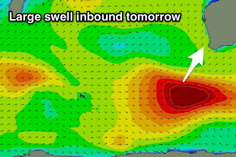 This swell was generated since Friday evening, with a deep and powerful low forming north of the Heard Island region, generating a fetch of severe-gale to storm-force W'ly winds in our south-western swell window.
The storm is currently weakening south of us, but continued to generate a fetch of gale to severe-gale W/SW winds until moving east out of our swell window.
A large long-period SW tending S/SW groundswell will fill in tomorrow, building rapidly and reaching 10-12ft across the South West swell magnets, 3ft+ in Mandurah and 2-3ft in Perth.
Winds will be fresh and gusty out of the SE tomorrow morning, favouring slightly protected spots, possibly holding all day if not tending a little more S/SE.
Wednesday will be excellent as the swell eases with an E/NE offshore across all locations, swinging S/SE into the afternoon. Margs should ease from 6-8ft, 2-3ft in Mandurah and 2ft in Perth.
The surf is due to become smaller Thursday but with less favourable S/SE winds.
Friday will become cleaner with an E/SE offshore, but the surf will remain on the small side. A small mid-period S/SW swell will fill in through the day, though only likely keep south magnets around 3-4ft, easing from a similar size Saturday.
This swell will be generated by a strong but late forming low in our southern swell window, with no size due around Mandurah or Perth.
Longer term some better sized S/SW groundswells are on the cards for early next week, producing by strong polar fronts forming late in our swell window.
Winds are a little tricky at this stage, so check back here Wednesday for more details.
Comments
Hey Craig any chance we could get your notes, the surf forecast and the WAMs saying the same thing. Tomorrow’s swell is a great example, the surf forecast is calling it 6 foot and peaking late in the day, your forecaster notes are calling it 10-12 ft while the WAMs are showing the peak of the swell hitting Margs around 6am.
Just finding it confusing whether I should be starting work late or finishing work early and whether I should be packing the 6’4” or the 8’2”
First world problems I know