Good run of swell and conditions from the weekend

Western Australia Surf Forecast by Craig Brokensha (issued Friday 1st March)
Best Days: Saturday morning, Sunday morning, Monday morning keen surfers in the South West, Tuesday, Wednesday
Recap
Average, deteriorating conditions and a small bump in swell yesterday across all locations, a bit bigger again today but with a moderate to fresh onshore wind as a front pushes into the state.
Today’s Forecaster Notes are brought to you by Rip Curl
This weekend and next week (Mar 2 - 8)
The front linked to today's onshore winds was stronger a couple of days ago and has generated a good large W/SW groundswell for tomorrow. In its earlier stages a fetch of W/SW gales were projected towards us, and we'll see this swell peak tomorrow to 6ft to occasionally 8ft across the South West, 2-3ft in Mandurah and 2ft in Perth. A drop in size should be seen through the day, smaller Sunday and easing from 4-6ft, 2ft and 1-2ft respectively.
Winds tomorrow will be great around Mandurah and Perth and out of the SE, but Margs looks a little dicey and best in protected spots with a light to moderate S/SE'ly, with sea breezes into the afternoon.
 Sunday will be great with an E/SE offshore ahead of sea breezes, smaller Monday with gusty SE winds across the South West (E/SE to the north).
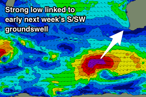
Our large long-period SW tending S/SW groundswell for Tuesday is still on track with an intense low due to form north of the Heard Island region this evening, drifting east-southeast while generating an initially tight but broadening fetch of severe-gale to storm-force W'ly winds in our south-western swell window. The storm will expand in scope late in our southern swell window and continue to generate severe-gale W/SW winds.
A large long-period SW tending S/SW groundswell should be generated, building rapidly through Tuesday and reaching 10-12ft across swell magnets into the afternoon, 3ft+ in Mandurah and 2-3ft in Perth.
Winds are looking good through the morning, though fresh and gusty out of the SE, tending more S/SE into the afternoon, favouring protected spots. Wednesday still looks excellent as the swell eases with an E'ly offshore, tending E/NE ahead of late sea breezes.
Conditions will be less than ideal Thursday with winds out of the S/SE as the swell continues to drop.
A secondary strong storm that was forecast to form is now looking much weaker but we should still see a fun new mid-period S/SW swell for late week with offshore SE winds, but more on this Monday. Have a great weekend!
Comments
Fuck ... I picked the right week to restart my FIFO career, and this is after a week or so of being bombarded by footage of OMA. I hope everyone gets good waves over the coming few days .
Heading down to Boddington for the shut Nicko?