Good swell and winds later weekend and early week

Western Australia Surf Forecast by Craig Brokensha (issued Friday 22nd February)
Best Days: Sunday and Monday mornings all locations
Recap
Strong large sets and workable waves across the South West yesterday morning with a peak in swell, easing back through the day and great this morning with an offshore wind and 4-5ft leftovers.
Mandurah was a bumpy though OK 2ft after the lack of recent swell, 1-2ft in Perth. Today both have eased back to 1-1.5ft with variable winds.
Today’s Forecaster Notes are brought to you by Rip Curl
This weekend and next week (Feb 23 - 28)
Conditions are still looking suss for tomorrow with a light to moderate NW breeze across the South West and further drop in swell. Perth and Mandurah should be clean with a light NE breeze but tiny.
Sunday and Monday are the days to look out for as we see our new W/SW groundswell fill in, followed by a reinforcing mid-period SW swell Monday.
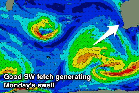 These swells are being generated by a slow moving storm that's currently south-west of us, with an initial good burst of W/SW gales now giving into broader but weaker SW fetch.
We should see a good W/SW groundswell from the initial fetch moving in, coming in at 5-6ft across the South West Sunday, 2ft in Mandurah and 1-2ft in Perth with a good SE offshore, possibly even E/SE.
The swell will ease into Monday but the reinforcing SW energy should keep Margs around 4-6ft most of the day, 2ft in Mandurah and 1ft to possibly 2ft in Perth. Winds look great again with an E/SE offshore ahead of sea breezes.
From here we'll be on a downwards trend with less favourable S/SE winds on Tuesday, similar Wednesday. Therefore make the most of Sunday/Monday.
Later in the week we'll probably see a couple of large swells developing as the westerly storm track fires up south-west of us, but more on this Monday. Have a great weekend!