Generally good winds and fun swells this period

Western Australia Surf Forecast by Craig Brokensha (issued Monday 29th October)
Best Days: Tuesday morning, Wedneday morning, Friday morning, Saturday morning
Recap
Tiny clean waves around Perth and Mandurah all weekend to 1-1.5ft, with a slight kick in size across the South West Saturday to 3-4ft with OK winds, cleaning up more through the morning Sunday as a slightly better groundswell filled in. Unfortunately sea breezes created average conditions as it kicked further into the afternoon.
This morning the swell was still up across the South West but with average S'ly winds, 1-2ft in Mandurah and a choppy tiny 1-1.5ft in Perth.
Today’s Forecaster Notes are brought to you by Rip Curl
This week and weekend (Oct 30 – Nov 4)
Winds should improve tomorrow morning across all locations as a high moves in from the west, swinging winds SE along with a reinforcing pulse of mid-period W/SW swell.
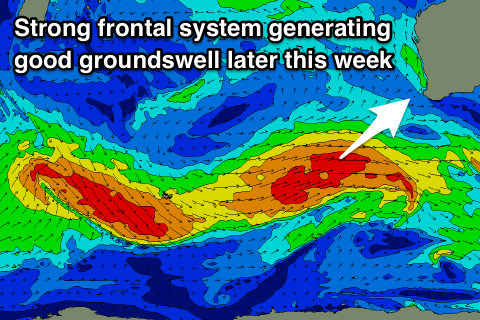
This mid-period swell was generated over the weekend by a small fetch of W/SW gales moving in north of the Heard Island region, and then east through our south-western swell window.
We should see 4-5ft sets tomorrow morning across the South West, increasing a touch through the day and then easing back from 4-5ft Wednesday morning. Mandurah and Perth should see 2ft sets and winds will swing even more offshore on Wednesday from the E/SE with the easing swell ahead of an onshore change later morning.
 The easing trend will be slowed into Thursday morning, while the change on Wednesday will be linked with a weak front projecting towards us, generating some more weak mid-period SW swell into the afternoon.
Winds will be onshore out of the W/SW creating average conditions on Thursday, with an early S/SE breeze around Mandurah and Perth but only tiny 1-1.5ft sets max.
Friday we'll see a larger SW groundswell filling in owing to a stronger polar frontal progression pushing up and towards us from tomorrow, developing in the Heard Island region and projecting north-east. A good fetch of W/SW tending SW gales should produce a good long-period SW groundswell, reaching 6-8ft across the South West into the afternoon across Margs, 2-3ft in Mandurah and 2ft in Perth.
Winds will improve and swing light to moderate SE creating good clean conditions, with Saturday still a little unsure as a possible inland trough across the North West deepens into a low and drifts south. This will likely see E'ly tending SW winds, but we'll have to review this on Wednesday.
Longer term a new long-period S/SW groundswell is on the cards for Sunday/Monday, though we'll have another look at this Wednesday.