Strong low dominates and spoils the forecast period

Western Australia Surf Forecast by Craig Brokensha (issued Monday 27th August)
Best Days: Margs early tomorrow morning, dawn Wednesday for desperate surfers, Saturday all locations, Sunday morning in the South West
Recap
Pumping waves across all regions on the weekend with another good pulse of SW groundswell on Saturday to 6-8ft across the South West, 2-3ft in Mandurah and 2ft in Perth.
Sunday was a little smaller but excellent again with clean 5-6ft waves in the South West, back to 2ft in Mandurah.
This morning a small low moved in a little quicker than expected on Friday bringing poor onshore conditions to the South West, cleaner though still bumpy around Perth and Mandurah.
Today’s Forecaster Notes are brought to you by Rip Curl
This week and weekend (Aug 28 – Sep 2)
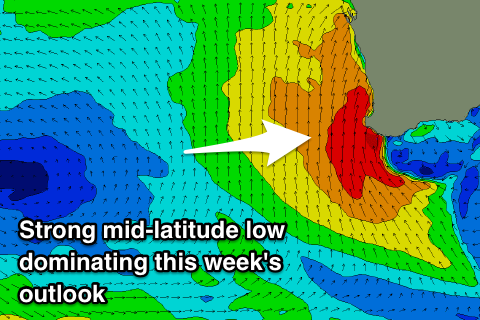
Tomorrow is looking quite interesting as a deep and powerful mid-latitude low froms and stalls to our west, bringing varying winds as a new long-period SW groundswell fills in.
With the axis of the low sitting west of Margs we're expected to see offshore E/NE-NE winds across the South West tomorrow morning, with onshore N/NW winds in Perth and Mandurah, swinging more W/NW across all coasts through the day.
 The new groundswell was generated over the weekend by a strong and intense polar low forming east of Heard Island, projecting a fetch of severe-gale to storm-force W'ly winds late in our swell window.
The swell will arrive early morning and build rapidly, but how much size we'll see before winds go onshore is to be seen.
Margs should reach 6-8ft through the day, smaller in Perth and Mandurah, but the'll be seeing larger levels of building W/NW windswell in any case.
As touched on last update, the mid-latitude low won't be a good swell producer with the strongest winds on its western flank aimed more towards Indonesia, with a weaker W/NW fetch on its northern flank.
The low is forecast to drift east and across us into Wednesday, directing gale-force S/SW winds into the coast through the day, with a very short period of variable breezes likely at dawn across all locations early morning.
The gales will kick up a large stormy S/SW swell through for Wednesday afternoon, likely to the 6-8ft range across the South West by dark, with 3-4ft waves in Mandurah, 3ft+ in Perth.
The low will move off slowly to the east resulting in a drop in swell on Thursday but winds look to remain onshore out of the S/SW across most locations, and with the swell out of the S/SW, protected locations will be tiny.
Friday unfortunately doesn't look much better with a weak front keeping SW winds across the South West, offshore out of the E/NE across Mandurah and Perth.
Swell wise, a mix of distant SW groundswell and closer-range S/SW groundswell are due to fill in through the day. Both swells aren't due to offer any real size for Mandurah and Perth who'll see those better winds. Only inconsistent 2ft sets are due Friday afternoon across the South West, 1-2ft in Perth as winds swing onshore. Margs should offer better sets in the 6ft range but with average conditions.
Saturday is looking much better as the swells ease from a similar size to Friday afternoon along with E/SE offshore winds.
Sunday looks smaller but with a possible new S/SW swell filling in across the South West under E/NE-NE winds.
Longer term there's nothing too significant until mid-late next week, but more on this Wednesday.