Great weekend, deteriorating next week

Western Australia Surf Forecast by Craig Brokensha (issued Friday 24th August)
Best Days: Saturday, Sunday, Monday magnets in the South West, Thursday Perth and Mandurah
Recap
Great waves the last two days with a large easing SW groundswell and offshore winds across the South West, dropping from an easy 8ft on the sets, with 3ft+ waves in Mandurah and 3ft surf in Perth yesterday.
The afternoon became a little wind affected across all locations, but this morning we've got a new SW groundswell keeping pumping 6ft+ surf across the South West and 2-3ft waves in Perth and Mandurah. Winds will remain favourable all day as the swell also hangs in there.
Today’s Forecaster Notes are brought to you by Rip Curl
This weekend and next week (Aug 25 - 31)
Today's reinforcing SW groundswell is the first of two, with the second coming from post-frontal W/SW gales on the backside of the pre-frontal W/NW gales generating the first pulse.
Margs should persist at 6ft+ tomorrow across the swell magnets, with 2ft to occasionally 3ft waves in Mandurah and Perth.
Conditions should be clean with an E/NE offshore, tending light to moderate onshore through the afternoon, similar Sunday but tending more W/NW into the afternoon. We'll see the swell easing back from 4-6ft and 2ft respectively.
Monday will be smaller and variable tending light offshore winds should again create clean conditions, best across the swell magnets in the South West, tiny around Perth and Mandurah.
 Moving into Tuesday and strengthening NW tending SW winds linked to a deep mid-latitude low forming directly off our region will result in a lay day.
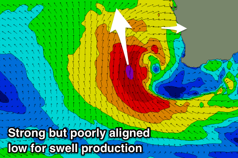
This low isn't expected to generate any meaningful swell for the South West, as the fetch of S/SW-S gales on its western flank will be aimed towards Indonesia. As it moves east into us on Wednesday though, Perth and Mandurah are expected to see a solid kick in size, but with onshore winds, with a window of S/SE breezes Thursday as the eye of the low pushes across us. We'll have to review this Monday.
The South West will see a new long-period SW groundswell Tuesday though, generated by a strong polar low forming south-west of us over the weekend, with a fetch of severe-gale to storm-force W/SW winds being produced.
This swell is due to build through Tuesday with those strong onshore winds, easing Wednesday but with variable likely onshore winds as the low moves across the region. We'll go over this again on Monday though as the models diverge regarding the development of the low directly off our coast.