XL stormy surf tomorrow, easing into Sunday and settling down through Monday/Tuesday

Western Australia Surf Forecast by Craig Brokensha (issued Friday 25th May)
Best Days: Novelty spots tomorrow, Perth and Mandurah Monday morning, protected spots in the South West Monday afternoon, Tuesday morning, Wednesday morning
Recap
A very small window of OK conditions early yesterday across all coasts before strong N'ly widns kicked in through the day.
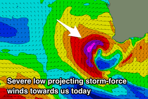
We've got full blown stormy conditions across all locations today as a severe low deepens right off our coast.
Today’s Forecaster Notes are brought to you by Rip Curl
This week and weekend (May 26 – Jun 1)
Currently a severe low is winding up west-southwest of Margaret River, with a fetch of severe-gale to storm-force winds being projected towards the southern WA coast.
The low is forecast to push into us this evening, before sliding off slowly to the east during tomorrow.
 We'll see the surf continuing to build through this afternoon, mostly consistent of low quality windswell, with XL groundswell for tomorrow morning, mixed in with the windswell.
Surfing options will be very limited to novelty breaks across the state with strong to gale-force and easing W/SW winds.
Size wise, we're looking at easy 15ft+ waves across the South West, 6ft around Mandurah and 4-5ft in Perth, easing through the day, smaller into Sunday with strong W/SW winds.
The ocean will settle a touch into Monday but conditions will remain onshore SW tending S/SW winds across the South West and a long-period SW groundswell in the mix. This has been generated by a strong polar low the last couple of days, with 8ft surf due to continue across the South West, with 3ft sets continuing across Mandurah and 2-3ft waves around Perth.
We may see a period of S/SE winds across Mandurah and Perth, creating a window of OK conditions in protected spots.
Our larger SW groundswell for Tuesday now looks a touch smaller, with trailing fetches of W/SW gales in the wake of the low providing 6-8ft waves in the South West, 2-3ft Mandurah and 2ft Perth.
The window of better winds is still on the cards, but they'll be best north of Margaret River and out of the E/NE through the morning Tuesday, with dawn NE tending N and then NW winds around Margs. We'll have one final look at this Monday.
Wednesday is likely to see similar winds as the SW groundswell eases, ahead of a low point Thursday morning as onshore winds return owing to an approaching cold front.
This looks to bring more swell though with average conditions late week, but more on this Monday. Have a great weekend!