Large swell pulses to come with generally favourable winds

Western Australia Surf Forecast by Craig Brokensha (issued Monday 23rd April)
Best Days: Perth and Mandurah Tuesday morning, Margs Wednesday morning, all locations Thursday morning, later Friday protected spots, Saturday, Sunday morning
Recap
Small poor waves on offer Saturday morning ahead of a large kick in W/SW groundswell through the afternoon, holding into Sunday mixed in with some local windswell. Perth and Mandurah offered some fun waves with early variable winds, while today was a bit smaller and poor across all locations with fresh onshore winds.
Today’s Forecaster Notes are brought to you by Rip Curl
This week and weekend (Apr 24 - 27)
As touched on in Friday's notes, winds will linger onshore across the South West tomorrow as the W/SW groundswell and windswell ease across all regions, but Perth and Mandurah should offer light morning offshore E/SE winds. Sets are due to ease back from 2ft across Mandurah and Perth, with onshore surf dropping from 4-6ft across the South West.
Wednesday morning will finally be offshore across the South West with a light E/NE breeze, but the swell is only expected to be around 3ft to maybe 4ft.
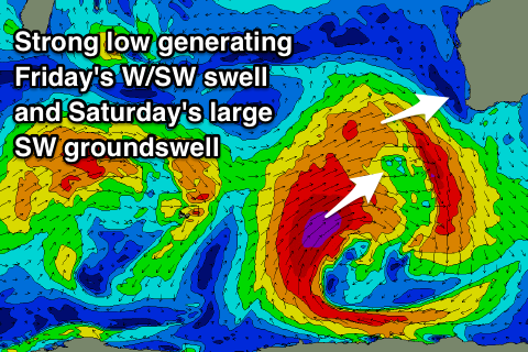
Our new SW groundswell due into the afternoon is still on track, with a good strong polar frontal progression that's currently south-west of us already acting on top an active sea state generated by a fetch of W/SW gales in the Heard Island over the weekend.
We're seeing additional gale to severe-gale winds, with a large SW groundswell due to build Wednesday and reach 6-8ft by dark at swell magnets, easing from 6ft to possibly 8ft Thursday morning.
 Mandurah and Perth are due to kick to 2ft+ and 2ft respectively late Wednesday, easing from 2-3ft and 2ft Thursday morning.
Winds Thursday morning look great and offshore from the E/NE, W/NW into the afternoon with an approaching front.
This front is now an extension of the secondary strong polar storm that was expected to generate Saturday's larger SW groundswell,
This larger swell is still on the cards, but we're due to see some W/SW energy in the mix as well.
Through the middle to end of this week we'll see a broad polar low forming between us and Heard Island, projecting a great fetch of severe-gale to storm-force SW winds through our south-western swell window, with W/SW gales further north in our western swell window.
The W/SW fetch will generate a moderate to large sized W/SW groundswell for Friday, peaking into the afternoon to an easy 6ft+ around Margs, 2-3ft in Mandurah and Perth. Winds look average though with S/SW breezes, possibly tending S/SE late as a high moves in from the west.
The larger SW groundswell is then due Saturday, peaking through the morning to a strong 10ft+ across the South West and 3ft in Mandurah with 2-3ft sets around Perth.
Winds are looking great with an E/SE offshore as the high continues to move easy, giving into mid-late afternoon sea breezes.
The swell should continue to ease through Sunday with a morning NE breeze tending NW into the afternoon.
Longer term another strong low looks to generate another large swell for Monday/Tuesday next week, but more on this Wednesday.