Good SW groundswell Wednesday/Thursday with workable winds

Western Australia Surf Forecast by Craig Brokensha (issued Monday 26th March)
Best Days: Protected spots in the South West and Mandurah/Perth Thursday morning, Friday morning exposed spots
Recap
Fun clean waves to 3ft across the South West on Saturday morning, building into the afternoon also with a hint of N/NW cyclone swell off Marcus in the mix.
Perth and Mandurah were tiny, but a slow increase in energy was seen through the day ahead of a peak in NW cyclone swell on Sunday.
The swell played out to script with Perth kicking to a solid though inconsistent 4ft range across magnets, some bigger bombs in Mandurah while Margs kicked to 6-8ft with gusty but easing offshore winds.
This morning the dream was over with the remnants of Marcus moving across the region bringing onshore winds with no decent size left across any region.

Shannon Worrall just metres from dry sand (Driftwood Photography)
Today’s Forecaster Notes are brought to you by Rip Curl
This week and weekend (Mar 27 – Apr 1)
Looking at the coming period and winds look to linger onshore across the South West tomorrow in the wake of the remnants of Marcus moving east through the Bight, while slightly better S/SE winds are due around Mandurah and Perth but with no size.
Our new SW groundswell for mid-week is still on track with a strong polar front that's formed east of Heard Island currently generating a fetch of W/SW gales in our south-western swell window.
The front is projecting north-east with a secondary system piggy backing on top of the original system, pushing closer to us tomorrow.
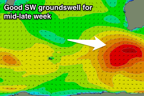 We should see a moderate to large sized SW groundswell produced, building Wednesday and peaking early Thursday across the state.
Margs should build to 5-6ft+ layer Wednesday with 2ft sets late in Mandurah and 1-1.5ft in Perth, with Thursday morning revealing 6ft to occasionally 8ft sets across the South West magnets, 2ft to possibly 3ft waves in Mandurah and 2ft sets in Perth.
Winds Wednesday will remain onshore across the South West but be SE further north ahead of sea breezes, while slightly cleaner conditions are due Thursday with a light S/SE-SE breeze in the South West and SE offshores further north.
Friday should be cleaner again as the swell continues to ease across all locations, smaller into the weekend with morning SE winds.
There's no new swell due until early-mid next week and at this stage this only looks to be in the small to moderate range, but more on this Wednesday.