Average week, larger surf for the weekend

Western Australia Surf Forecast by Craig Brokensha (issued Monday 12th March)
Best Days:
Recap
Improving conditions through Saturday with strong but SE tending E/SE winds with a fun sized groundswell across the South West, tiny and 1-1.5ft in Mandurah, minimal in Perth.
Sunday was a bit smaller with strong offshore winds which eased off into the afternoon.
This morning we've got tiny to flat conditions across Mandurah and Perth with clean fun leftover sets to 3ft across the South West.
Today’s Forecaster Notes are brought to you by Rip Curl
This week and weekend (Mar 13 – 18)
As touched on last update, there's not much on the cards for the coming days until late week.
We'll see good clean conditions tomorrow across magnets with a fresh but easing E/NE tending NE wind though hardly any size. Head to the most exposed breaks across the South West for 2-3ft leftovers, flat to the north.
Wednesday should be clean again but with no decent swell.
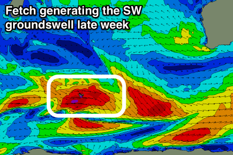 Our inconsistent long-period SW groundswell for Thursday afternoon and Friday morning is still on track, with a great fetch of gale to severe-gale W/NW winds moving east-southeast through our swell window. While not ideal the strength of the fetch is great and we should still see an increase in size Thursday afternoon to 4-5ft later in the day, with a peak overnight, easing from a similar size Friday morning.
Mandurah isn't expected to see much size with infrequent 1-2ft sets, tiny in Perth.
Winds on Thursday look poor with a trough moving in bringing SW breezes, lingering Friday but possibly more variable through the morning, but still not great.
As we move into the weekend, a polar front is forecast to be projected up and into us, bringing fresh onshore winds Saturday and a building windswell, followed by a large groundswell Sunday.
At this stage we're looking at sets to 8ft in the South West, 2-3ft in Mandurah and 2ft in Perth with possible S/SE-SE winds, but we'll have a closer look at this Wednesday.
Longer term some good S/SW groundswell is due next week of a flurry of strong polar frontal activity projecting towards Victoria, but more on this next update.