Fun swell Sunday with early offshores, new swell Tuesday with a better groundswell late week

Western Australia Surf Forecast by Craig Brokensha (issued Friday 16th February)
Best Days: Early Sunday morning in the South West, Tuesday morning Perth and Mandurah, Wednesday morning in the South West, Friday morning all locations
Recap
Clean conditions yesterday morning with a gusty offshore wind but small easing swell from 3-4ft across the South West, tiny to the north.
This morning it was smaller again with magnets across the South West the only option.
Today’s Forecaster Notes are brought to you by Rip Curl
This weekend and next week (Feb 17 – 23)
Tomorrow should be a lay day as the swell continues to drop away with less than ideal S/SE winds across the South West and possible weak onshore breeze to the north, though no swell.
Sunday is still looking fun with a very inconsistent SW groundswell that was generated south of South Africa earlier in the week due to peak.
 The swell should build later tomorrow but a peak is due Sunday morning to a very infrequent 3-5ft across swell magnets, easing through the day.
Winds have shifted a little more to the SE for Sunday morning which is a little unfortunate owing to an inland surface trough and approaching cold front, shifting more onshore late morning. Monday then looks poor with small leftover surf and a lingering SW breeze.
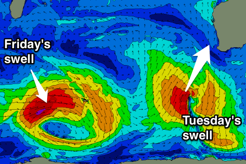
Our new pulse of W/SW swell for Tuesday is still on track, with a small mid-latitude low that's currently in the Indian Ocean, north of Heard Island.
A fetch of strong W/SW winds are being projected towards us, producing a small W/SW swell for Tuesday, while a secondary fetch of less favourably aligned S/SW gales in our southern swell window should produce a reinforcing S/SW groundswell arriving at a similar time through Tuesday.
The W/SW swell should provide 1-2ft sets across Perth and Mandurah through Tuesday, with the S/SW groundswell building to 4-5ft+ or so by late morning across the South West under gusty S/SE tending SE winds ahead of sea breezes.
The swell should then ease Wednesday under fresh E/SE offshores.
Longer term a new long-range and inconsistent SW groundswell is due late week, generated by a strong low forming south of South Africa this weekend,. A fetch of gale to severe-gale W'ly winds should move east across the Heard Island region before weakening once east and closer to us, producing a moderate to large long-period SW groundswell.
We're probably looking at a peak in swell around 6ft to occasionally 8ft across Margs Friday morning, with 2ft+ sets in Mandurah and 1-2ft waves in Perth. Winds also look favourable but we'll review this Monday. Have a great weekend!
Comments
Fellas where have the detailed reports been throughout the week for WA?
It's all I rely on when planning my weeks...
Craig’s back from leave Monday.. they’ll resume then.