Good swell for Wednesday, cleanest and easing Thursday

Western Australia Surf Forecast by Craig Brokensha (issued Monday 5th February)
Best Days: Wednesday in protected spots, Thursday morning, Saturday and Sunday mornings across the South West
Recap
A slight increase in swell Saturday morning with workable winds in northern corners across the South West, while Sunday saw light onshore winds as the swell 'peaked'.
This morning conditions were a bit cleaner but the swell average and easing from 2ft+ across the South West with 0.5-1ft of windswell to the north.
Today’s Forecaster Notes are brought to you by Rip Curl
This week and weekend (Feb 6 - 11)
Give the surf a miss tomorrow as we'll be starting from a tiny to flat base with freshening onshore winds.
This onshore breeze will be linked to good slow moving mid-latitude low that's formed to our south-west.
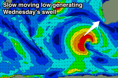 We're seeing a low moving fetch of W/SW-SW gales being generated through our south-western swell window.
The slow moving nature of the low will help generate a large SW groundswell for the state, building later tomorrow and peaking through Wednesday.
We should see the South West come in the 6ft+ range across magnets, 2-3ft in Mandurah and 2ft in Perth.
Moderate to fresh S/SE winds will only favour protected spots on Wednesday, but Thursday looks great with E/SE offshores and easing surf from the 4-5ft range across the South West, 2ft in Mandurah and 1-1.5ft in Perth.
Friday will see the swell continuing to ease with less favourable SE tending S/SE winds.
Into the weekend some small reinforcing S/SW swell is expected from broad but relatively weak polar frontal activity south-southwest of us through the rest of the week.
The best pulse is due on Saturday, reaching the 4ft range across the South West, but only tiny to the north and around 1-1.5ft, with 1ft waves in Perth. SE winds should create good conditions during the morning, with slowly easing surf Sunday with a better E/SE offshore.
Longer term a strong polar low is expected to generate a good S/SW groundswell for early/mid next week, but more on this Wednesday.
Comments
Hi Craig, where do you get your wind info from because BOM shows the winds being more from the southerly quadrant for Sat/Sun than what you are calling?
Yeah EC has E/SE Saturday and S'th Sunday, so still moving around..
OK so how do you say "Sunday with a better E/SE offshore." off the back of the above?
Because GFS has a morning E/SE breeze.
Latest update just in for GFS is sticking with SE Saturday and E/SE Sunday.
GFS seems more optimistic on the whole which I don't think I agree with given the weather patterns. ECMWF has it closer to BOM, more S than E.
It has been a super mild summer with lots of S winds. Hopefully it turns soon and we get back into out E patterns.
That front seems to be a little ways north and aimed perfectly at the mid coast....
Yep, should be 2ft Friday.