Waves for the South West, tiny to the north

Western Australia Surf Forecast by Craig Brokensha (issued Wednesday 17th January)
Best Days: The South West Friday mid-late morning with the building swell, Saturday morning, protected spots in the South West Sunday, Monday morning and Tuesday morning
Recap
Another pumping day of surf yesterday with a large reinforcing SW groundswell for the South West, coming in at 8ft on the sets still with offshore winds persisting all day (variable into the evening), while Mandurah saw fun clean 2ft sets, tiny in Perth.
This morning the swell was smaller with average S'ly winds across the South West, clean 1-2ft leftovers in Mandurah and a pulse to 1-2ft in Perth.
Today’s Forecaster Notes are brought to you by Rip Curl
This week and weekend (Jan 18 - 21)
We'll continue to see the swell ease through tomorrow as average S/SE winds persist across all locations, but into Friday winds will swing back offshore from the E/SE with a building SW swell.
This mid-period SW swell has been generated the last couple of days by a weak low traversing the polar shelf.
The swell will be best suited to the South West, with small 2-3ft waves in the morning, increasing to 3-4ft through the afternoon as winds swing S/SE. No size is expected around Mandurah or Perth.
 Easing surf is expected Saturday from 3ft+ across Margs swell magnets with E/SE offshores again through the morning.
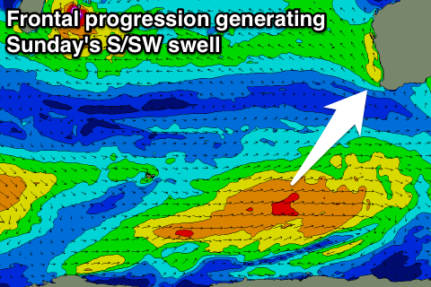
Into Sunday we'll see a stronger increase in S/SW groundswell from a polar frontal progression develop in the Heard Island region this afternoon.
An elongated fetch of strong to gale-force W/SW winds will move slowly east-northeast through our swell window, with a fun sized swell due to be generated for Sunday.
We should see Margs offering 4-5ft+ sets across magnets, 1-1.5ft in Mandurah and only 1ft around Perth. Winds will unfortunately swing fresh S/SE as a high pressure system moves in from the west.
An improvement in conditions is likely Monday as winds swing SE and the swell eases.
Longer term a secondary frontal system looks to generate a similar if not slightly smaller swell for Tuesday, but more on this Friday.
Comments
G'day Craig, any chance of the L that sits off the NW on Sunday developing into a TC?
Not that system, but possibly off the Kimberley Coast early next week.
Where's the best place to check this sort of info?
Tropical Tidbits is great for model updates as quick as you can get them.. https://www.tropicaltidbits.com/analysis/models/?model=gfs®ion=aus&pkg=mslp_pcpn_frzn&runtime=2018011812&fh=6
Also the BOM weekly tropical climate notes: http://www.bom.gov.au/climate/tropical-note/
And MJO forecasts: http://tparc.mri-jma.go.jp/TIGGE/tigge_MJO.html