Light at the end of the tunnel

Western Australia Surf Forecast by Craig Brokensha (issued Friday 28th July)
Best Days: Later Sunday Perth, protected spots Tuesday, Wednesday
Recap
A window of cleaner conditions around Perth and Mandurah yesterday morning with NE winds and 2-3ft surf. Margs was solid but choppy with a gusty N/NE breeze.
Today we're seeing large storm-surf developing across all locations with strong onshore winds. A good day to avoid the beach and surf.
This weekend and next week (Jul 29 – Aug 4)
There's been no change to the weekend forecast, with stormy XL waves due to continue across the South West tomorrow with large messy waves further north, owing to a vigorous mid-latitude low currently sitting off our south-west coast.
A fetch of gale to severe-gale W/SW-SW winds are being aimed through our south-western swell window, with easing XL surf from the 12ft+ range tomorrow morning and 3-5ft further north.
Strong W/SW winds will persist all day, while a secondary front pushing into us later in the afternoon will keep fresh W/SW winds hitting the coast into Sunday, tending moderate W/NW into the afternoon.
 The period of variable winds into the mid-late afternoon for Perth and Mandurah is still a chance, with surf coming in around 2-3ft.
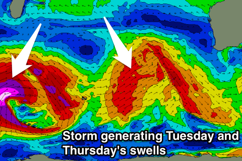
A vigorous polar front that's currently west of Heard Island and generating a fetch of W/SW gales in our far swell window will project north-east over the coming weekend, strengthening and broadening west of us before pushing across us Monday.
The swell from this system has been upgraded and we should see an XL W/SW groundswell filling in Tuesday, reaching 10-12ft across the South West and 3ft around Perth and Mandurah.
Monday will be poor with strong NW tending S/SW winds, but Tuesday and Wednesday are finally looking cleaner. Tuesday should see S/SE winds, creating cleaner conditions in protected spots, with a light E/NE offshore as the swell eases Wednesday.
Longer term, our larger long-period SW groundswell is still on track for Thursday and Friday, generated by a very strong and broad polar low. Unfortunately winds look to swing back onshore from the W for this swell, but more on this Monday. Have a great weekend!