Onshore winds and large stormy surf

Western Australia Surf Forecast by Craig Brokensha (issued Friday 14th July)
Best Days: No great days, early Tuesday keen surfers, (possibly Saturday morning)
Recap
A terrible weekend of waves with onshore winds both Saturday and Sunday with a building swell on the former.
Today winds tended offshore and conditions cleaned right up across all locations with a mix of easing SW swell and new long-period W/SW groundswell.
It looks like the W/SW groundswell has come in a touch over forecast with large consistent 8ft waves in the South West, 3ft in Mandurah and 2-3ft around Perth.
Winds should remain good into this afternoon as the swells starts to ease.
This week and weekend (Jul 18 – 23)
Today was the only real window for a clean wave, as fresh to strong N/NE winds at dawn tomorrow will tend more N'ly and strengthen further through the day, creating poor conditions.
This is linked to a deepening mid-latitude low approaching from the west.
Margs should be easing from 4-5ft on the sets with fading 2ft sets to the north.
Our large long-period W/SW groundswell for Wednesday is still on track, with a vigorous polar front developing under South Africa, generating a fetch of severe-gale to storm-force W/SW winds while pushing east through the southern Indian Ocean.
The swell is expected to arrive Wednesday morning and build to 10ft across the South West with 3ft sets in Perth and Mandurah, but the remnants of the front will take the form of the mid-latitude low west of us tomorrow.
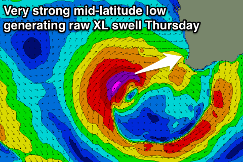 This low will deepen significantly tomorrow afternoon and evening, projecting a fetch of storm-force W/SW winds towards the state before weakening while pushing across us slowly Wednesday evening.
An additional raw XL W/SW swell will be generated for later in the day and more so Thursday morning coming in at 15ft+ across the South West and 3-4ft in Perth and Mandurah.
Unfortunately due to the slow moving nature of the low we'll see poor strong tending gale-force W/NW winds across all regions Wednesday, strong from the W Thursday.
Into Friday another front approaching from the west-southwest will attach itself to the back of the mid-latitude low, keeping onshore W/SW winds blowing across all locations with easing amounts of W/SW swell.
There's an outside chance of variable winds Saturday morning but the swell will be a mix of inconsistent long-range energy and mid-period SW swell. Margs is likely to be around 4-6ft, with 2ft waves further north.
Longer term small to moderate mid-period swells are due into early next week ahead of a larger W/SW groundswell mid-next week. This looks to be with persistent onshore winds though, so it looks like winter has truly set in.