Large easing swell tomorrow with light morning winds

Western Australia Surf Forecast by Craig Brokensha (issued Monday 19th September)
Best Days: Tuesday morning both regions, Perth Wednesday morning, Saturday morning both coasts
Recap
Pumping waves Saturday with a large clean easing SW groundswell with offshore tending variable winds. The South West eased from 8ft+, with 2ft to occasionally 3ft sets around Perth and Mandurah.
Sunday was smaller but onshore in the South West, with cleaner conditions to the north.
Today a large onshore swell was on the build across the South West, with smaller workable waves to the north.
This week (Sep 20 - 23)
The large swell building across the coast today is expected to peak early tomorrow morning across the state, with large easing 8-10ft waves due across the South West and 3ft waves in Perth.
A light variable wind is expected to develop across the South West, but conditions will still be raw and lumpy with no real offshore to iron it out. In asying this it should clean up through the morning and semi-protected locations would be the pick before winds come up from the NW into the afternoon.
Perth should see light offshore E'ly winds before late sea breezes kick in.
 Wednesday will be smaller and poor in the South West with a fresh NW wind, while Perth should see a morning NE'ly and easing 1-2ft sets.
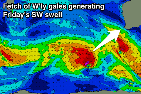
A slight lift in SW groundswell is due Thursday from a relatively weak mid-latitude front pushing towards us over the coming days but behind this a stronger front is expected to generate a larger SW swell for Friday. A better fetch of gale to severe-gale W/NW winds will be generated in our south-west swell window before the system in a much weaker form pushes up and into us on Thursday evening.
We should see a moderate to large sized SW groundswell from this system, peaking 6-8ft in the South West and 2ft in Perth.
Unfortunately winds look to be onshore from the SW tending S/SW in the wake of the front Thursday evening, with cleaner conditions Saturday as the swell eases. The day before on Thursday though early NE winds are due around Perth with onshores in the South West.
Longer term we've got an active period of swell ahead from Sunday afternoon as a series of polar and mid-latitude storms fire up in our swell window.
Winds look to be a problem though as the systems push high close to us, but we'll review this again Wednesday.