Large swell building Friday, pumping while easing Saturday

Western Australia Surf Forecast by Craig Brokensha (issued Wednesday 14th September)
Best Days: Protected spots Friday afternoon, Saturday, early Sunday, Tuesday
Recap
Clean surf the last couple of days but small and only to 3-4ft in the South West yesterday, a touch stronger but inconsistent today. Perth and Mandurah have been tiny.
This week and weekend (Sep 15 - 18)
Tomorrow is still set to be average with a slight kick in new SW groundswell across the South West to 4-6ft, but with onshore W/NW winds. Perth will be clean early but tiny and only 1ft.
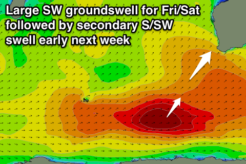
Into Friday our strong pulse of building SW groundswell looks to be met with more favourable winds.
This swell which has been produced by a vigorous polar low firing up south-east of South Africa, traversing the polar shelf towards us the last few days.
The swell should arrive through the day and build strongly late across the South West to 8-10ft+ easing from a similar size Saturday morning.
 Perth isn't due to see any major size late, easing back from 2ft to possibly 3ft Saturday morning.
Conditions on Friday look OK in protected locations with a S/SE breeze across the South West (possibly S'ly at dawn) and then Saturday looks excellent with an E/NE'ly tending variable breeze.
Sunday may see a variable wind early as the SW swell continues to ease, but Perth will definitely see offshores with fading 1-2ft sets.
Next week onwards (Sep 19 onwards)
As touched on last update, more large S/SW groundswell is due into early next week. This will be produced by a two pronged polar frontal progression developing in the Heard Island region this evening.
A pre-frontal fetch of W/NW gales will be closely followed by post-frontal W/SW winds, generating a moderate sized S/SW groundswell for Monday morning, with a secondary front piggy-backing over the top, projecting north-east towards us Sunday and into Monday.
A larger S/SW swell will develop later in the day Monday, easing back Tuesday. Size wise we're looking at a peak around 8-10ft+ again around Margs, and 2ft+ in Perth.
Conditions on Monday again will be average with S/SW winds, but a high is due to move in quickly Tuesday resulting in winds tending light E/NE. We'll have to confirm this Friday though.